IMAGES TAKEN NEAR TO
Stoneywood Park, DENNY, FK6 5HS
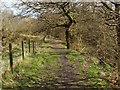
Introduction
This page details the photographs taken nearby to Stoneywood Park, FK6 5HS by members of the Geograph project.
The Geograph project started in 2005 with the aim of publishing, organising and preserving representative images for every square kilometre of Great Britain, Ireland and the Isle of Man.

There are currently over 7.5m images from over14,400 individuals and you can help contribute to the project by visiting https://www.geograph.org.uk
Image Map
Images are licensed for reuse under creativecommons.org/licenses/by-sa/2.0
Notes
- Clicking on the map will re-center to the selected point.
- The higher the marker number, the further away the image location is from the centre of the postcode.
Image Listing (20 Images Found)
Images are licensed for reuse under creativecommons.org/licenses/by-sa/2.0
Image
Details
Distance
1
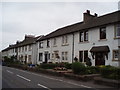
Stoneywood Park, Stoneywood
Houses on main street at Stoneywood
Image: © Angela Mudge
Taken: 20 Jul 2006
0.03 miles
2
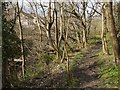
Right of way to Stoneywood
For the previous part of the route, see Image The present photo is a view back along the path; the River Carron is at the bottom of the slope that is just to the left of the path.
Visible through the trees, on the other side of the river, are some of the houses in Old Mill Way, Stoneywood.
For the next part of the route, see Image
Image: © Lairich Rig
Taken: 19 Apr 2010
0.08 miles
3
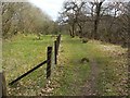
Right of way to Stoneywood
For the previous part of the route, see Image; the long embankment that is mentioned there can be seen to the left of the fence.
For the next part of the route, see Image
Image: © Lairich Rig
Taken: 19 Apr 2010
0.09 miles
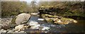
4
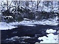
Stoneywood, River Carron
Frozen over where the current is slower, note the 4ft. icicles hanging from the rocks.
Image: © Robert Murray
Taken: 5 Dec 2010
0.10 miles
5
Right of way to Stoneywood
For the previous part of the route, see Image
The path continues through the gate that can be seen ahead. However, before going that way, I made a brief detour to the right, heading down the slope towards the river: Image
A final potential obstacle before reaching Stoneywood is the motorway; however, at that point, the path continues along the bank of the River Carron, and is directed underneath a bridge that carries the motorway over the river.
Image: © Lairich Rig
Taken: 19 Apr 2010
0.15 miles
6
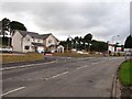
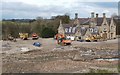
New houses, Stoneywood
A new housing development opposite the site of the Carrongrove paper works.
Image: © Richard Webb
Taken: 10 Sep 2011
0.18 miles
7
The River Carron at Stoneywood
Image: © Lairich Rig
Taken: 19 Apr 2010
0.18 miles
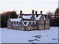
9
Carrongrove House
Its bleak surroundings reflect the recent demolition of the adjacent structures that made up Carrongrove Paper Mill; see Image
For a similar view without the vehicles, see Image For a wintry view of the building, see Image
See http://portal.historic-scotland.gov.uk/designation/LB50279 (at Historic Environment Scotland) for the listed building details of the house, which also seems to be referred to almost as frequently as "Carronglen House"; according to the report just cited, it was originally "Glencarron".
Image: © Lairich Rig
Taken: 19 Apr 2010
0.20 miles
10

Carrongrove House (unoccupied)
See www.geograph.org.uk/photo/1831291 for comparison and detailed info.
Image: © Texas Radio and The Big Beat
Taken: 24 Aug 2010
0.21 miles