IMAGES TAKEN NEAR TO
Redding Industrial Estate, FALKIRK, FK2 9TT
Introduction
This page details the photographs taken nearby to Redding Industrial Estate, FK2 9TT by members of the Geograph project.
The Geograph project started in 2005 with the aim of publishing, organising and preserving representative images for every square kilometre of Great Britain, Ireland and the Isle of Man.

There are currently over 7.5m images from over14,400 individuals and you can help contribute to the project by visiting https://www.geograph.org.uk
Image Map
Images are licensed for reuse under creativecommons.org/licenses/by-sa/2.0
Notes
- Clicking on the map will re-center to the selected point.
- The higher the marker number, the further away the image location is from the centre of the postcode.
Image Listing (31 Images Found)
Images are licensed for reuse under creativecommons.org/licenses/by-sa/2.0
Image
Details
Distance
1
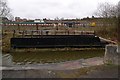
Swing bridge on Union Canal
This small swing bridge once provided access to the Nobel munitions factory at Reddingmuirhead on the far bank.
The site is being redeveloped for housing now.
Image: © Rob Burke
Taken: 4 Apr 2009
0.04 miles
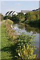
2
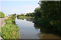
Canal Basin at Redding
Looking east towards the widening of the canal opposite what is now the industrial estate at Redding.
Image: © Anne Burgess
Taken: 26 Aug 2013
0.04 miles
3
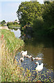
Swans on the Canal
The parents and four cygnets came over to take a look at me, but lost interest when they saw I had no food to give them. In the background, on the other side of the canal, is Image
Image: © Anne Burgess
Taken: 26 Aug 2013
0.05 miles
4
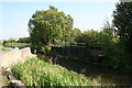
Old Swivel Bridge
It took me a few moments to realise that the ironwork on the far side of the canal is an old swivel bridge, and indeed it is marked on the 1864 six-inch map as such. It carried an industrial railway line, probably narrow gauge, over the canal. See Image
Image: © Anne Burgess
Taken: 26 Aug 2013
0.05 miles
5
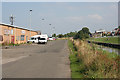
Redding Industrial Estate
For a short distance here the canal emerges from its quiet leafy course and passes alongside the units that make up the small industrial estate - perhaps a hint of the industry that once the canal depended on?
Image: © Anne Burgess
Taken: 26 Aug 2013
0.07 miles
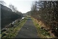
7
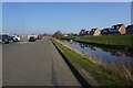
Union Canal west of Redding
West of Redding and HM Young Offenders Facility the canal loses its towpath temporarily, having been adopted by a road that serves an industrial estate.
Image: © Chris Heaton
Taken: 9 Aug 2009
0.11 miles
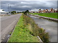
8
Houses by the Canal
These houses are in the imaginatively named Canalside Drive, on the south side of the Union canal.
Image: © Anne Burgess
Taken: 26 Aug 2013
0.12 miles
10
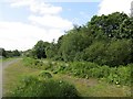
Industrial site, Reddings
Early 20th century maps show an explosive works occupied this site, to the west of Reddings Colliery.
Image: © Richard Webb
Taken: 30 May 2014
0.13 miles