
IMAGES TAKEN NEAR TO
Teith Road, DOUNE, FK16 6AL
Introduction
This page details the photographs taken nearby to Teith Road, FK16 6AL by members of the Geograph project.
The Geograph project started in 2005 with the aim of publishing, organising and preserving representative images for every square kilometre of Great Britain, Ireland and the Isle of Man.

There are currently over 7.5m images from over14,400 individuals and you can help contribute to the project by visiting https://www.geograph.org.uk
Image Map
Images are licensed for reuse under creativecommons.org/licenses/by-sa/2.0
Notes
- Clicking on the map will re-center to the selected point.
- The higher the marker number, the further away the image location is from the centre of the postcode.
Image Listing (14 Images Found)
Images are licensed for reuse under creativecommons.org/licenses/by-sa/2.0
Image
Details
Distance
![Deanston, mill lade [3]](https://s2.geograph.org.uk/geophotos/02/69/78/2697806_43681120_120x120.jpg)
2
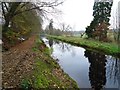
Deanston Mill, lade
This stretch outside the village but the name remains. The water looks serene but there is a strong current flowing.
Image: © Robert Murray
Taken: 15 Nov 2011
0.10 miles
3
![On the Teith [3]](https://s2.geograph.org.uk/geophotos/02/69/78/2697802_930b75d7_120x120.jpg)
On the Teith [3]
The farmland of Clarkton astride the right bank of the river.
Image: © Robert Murray
Taken: 15 Nov 2011
0.16 miles
4
![Deanston Mill, lade [2]](https://s3.geograph.org.uk/geophotos/02/69/78/2697819_928e4db6_120x120.jpg)
Deanston Mill, lade [2]
And Autumn leaves lie thick and still. The company have had a lot of overhanging trees felled recently. Canny have leaves in our whisky.
Image: © Robert Murray
Taken: 15 Nov 2011
0.18 miles
5
![Deanston, mill lade [2]](https://s2.geograph.org.uk/geophotos/02/69/77/2697770_fe6490ca_120x120.jpg)
Deanston, mill lade [2]
View upstream of what looks very much like a canal. About six foot deep and approximately twenty wide it's a big lade delivering a lot of water to the distillery where after use and abstraction most is returned to the Teith. A fine example of Georgian engineering.
See RCAHMS site record for view of lade when empty for maintenance on tunnel. http://canmore.rcahms.gov.uk/en/site/305252/details/deanston+deanston+mills+culverted+lade+section/
Image: © Robert Murray
Taken: 15 Nov 2011
0.19 miles
6
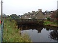
Deanston, mill lade
The tunnel takes the lade into the distillery under the back gardens of (the) First Division houses to the right.
See also RCAHMS site report of maintenance on lade and tunnel http://canmore.rcahms.gov.uk/en/site/305252/details/deanston+deanston+mills+culverted+lade+section/
Image: © Robert Murray
Taken: 15 Nov 2011
0.20 miles
7

No ball games sign
One of several identical Stirling District Council notices in Deanston. The village has its own football team and pitch but residents were at one time plagued by youths who preferred practising in the streets.
Image: © kim traynor
Taken: 30 Aug 2013
0.21 miles
8
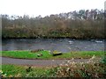
Deanston, River Teith
The road leads to the water treatment works (yes, on a classic salmon river). The Buchany Burn can be glimpsed falling into the river on the far bank.
Image: © Robert Murray
Taken: 15 Nov 2011
0.21 miles
9

Deanston, Teith Road
Mill workers housing built in the 19th. century. the row on the right is called (the) First Division and was built for managers. The building on the right is (the) Second Division and housed the next level down from the exalted across the road. Interesting that (the) First Division has a level lower than the road and sits on the same level as the lade/canal which passes by in an underground tunnel very near the back of the houses.
See RCAHMS site report http://canmore.rcahms.gov.uk/en/site/305252/details/deanston+deanston+mills+culverted+lade+section/
Image: © Robert Murray
Taken: 15 Nov 2011
0.23 miles
10
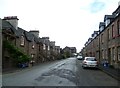
Workers' housing, Teith Road
The old Deanston Mill can be seen in the distance.
Image: © kim traynor
Taken: 30 Aug 2013
0.23 miles