IMAGES TAKEN NEAR TO
Empsons Close, DAWLISH, EX7 9BG
Introduction
This page details the photographs taken nearby to Empsons Close, EX7 9BG by members of the Geograph project.
The Geograph project started in 2005 with the aim of publishing, organising and preserving representative images for every square kilometre of Great Britain, Ireland and the Isle of Man.

There are currently over 7.5m images from over14,400 individuals and you can help contribute to the project by visiting https://www.geograph.org.uk
Image Map (Loading...)


Getting Data...Please wait
Leaflet Map data © OpenStreetMap
Images are licensed for reuse under creativecommons.org/licenses/by-sa/2.0
Notes
- Clicking on the map will re-center to the selected point.
- The higher the marker number, the further away the image location is from the centre of the postcode.
Image Listing (83 Images Found)
Images are licensed for reuse under creativecommons.org/licenses/by-sa/2.0
Image
Details
Distance
1
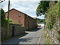
Stonelands Mews, Weech Road, Dawlish
A modern apartment building on the site of the former Stonelands Farm.
Image: © Stephen Craven
Taken: 14 Jul 2021
0.04 miles
2
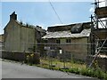
The old vicarage, Weech Road, Dawlish
Given its former ecclesiastical use and grade II listing (list entry 1164525) it is surprising that this building has been allowed to get into such a state of ruin. But it was already said to be in a poor state, though still roofed, in 2008 Image The listing describes it as 'House, probably late C17 or early C18. and associated stable and gig or coach house'.
Image: © Stephen Craven
Taken: 14 Jul 2021
0.04 miles
3
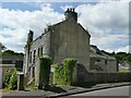
The old vicarage, Weech Road, Dawlish (2)
Given its former ecclesiastical use and grade II listing (list entry 1164525) it is surprising that this building has been allowed to get into such a state of ruin. But it was already said to be in a poor state, though still roofed, in 2008 Image The listing describes it as 'House, probably late C17 or early C18. and associated stable and gig or coach house'. See also Image
Image: © Stephen Craven
Taken: 14 Jul 2021
0.05 miles
4
The Old Vicarage, Weech Road, Dawlish
"The owner of a crumbling grade two listed building in Teignbridge faces legal action unless something is done to stop the building collapsing. The Old Vicarage in Weech Road, Dawlish, is owned by a London man and has been empty for 20 years. The property was listed in 1951 as a grade two building of special architectural and historic importance. The original house is thought to date from the 17th century and a later wing was added in 1846. It is constructed of traditional Devon cob with a slate roof, historic trusses and stable pavers. The property is a good example of a simple but historic curtilage building, and is situated close to the Dawlish Conservation Area. But now there are holes in the roof, pigeons live in the loft space, the windows are broken and part of the ground floor is missing" http://www.dawlish.com/News/Legal-threat-1673.aspx The above piece appeared in 2005; the full account of the situation then is at http://www.teignbridge.gov.uk/media/pdf/a/5/EX2005_June_13_Rep_Weech_Road_Dawlish.pdf . Little seems to have changed.
According to http://www.devon.gov.uk/walk86-dawlishdiscoverywalk.pdf , "many years ago there was an idea to run a railway line around the back of Dawlish and this building was earmarked as the potential station."
Image: © Derek Harper
Taken: 9 Nov 2008
0.05 miles
5
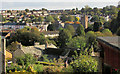
Western Dawlish
A view from Empsons Hill. The building in a sad state towards the left is also shown at Image It is listed as "13, Weech Road and former gig house" https://historicengland.org.uk/listing/the-list/list-entry/1164525 , "gig" as in "coach". See https://dawlish.com/thread/details/44940 . http://web.archive.org/web/2016*/http://www.teignbridge.gov.uk/media/pdf/a/5/EX2005_June_13_Rep_Weech_Road_Dawlish.pdf has the following "A recent inspection has revealed that the main building and outbuilding still require works to make them wind and weatherproof and prevent collapse. The main building has holes in the roof, dry rot, unsecured open windows and doors and internally has part of the first floor missing. There is running water through the roof and rising and penetrating damp. The unoccupied outbuilding is constructed of cob with slate roof, historic trusses and stable pavers. It is a good example of a simple but historic curtilage building. Sections of the outbuildings cob wall have degraded to an extent that partial collapse is possible."
To the right is St Gregory's church, grade II* listed https://historicengland.org.uk/listing/the-list/list-entry/1164203 .
Image: © Derek Harper
Taken: 20 Oct 2019
0.06 miles
6
Weech Road, Dawlish
Looking towards the trees in the grounds of Stonelands House, off Aller Hill.
Image: © Robin Stott
Taken: 27 Jun 2009
0.06 miles
7
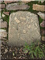
County Bridge Marker on Aller Hill, Dawlish
County Bridge Marker set in a stone wall near a post box on the northwest side of Aller Hill opposite Weech Road, 100 metres north of Stonelands Bridge in Dawlish parish. The stone marks the extent of roadway adjoining the bridge that the County was obliged to maintain.
Milestone Society National ID: DV_DAW02br
Image: © T Jenkinson
Taken: 31 Jan 2014
0.07 miles
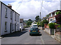
8
Junction on Empsons Hill
With Weech Road (opposite).
Image: © Derek Harper
Taken: 20 Oct 2019
0.07 miles
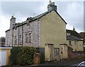
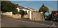
9
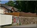
Wall postbox, Aller Hill, Dawlish
A GR postbox opposite the end of Weech Road.
Image: © Stephen Craven
Taken: 14 Jul 2021
0.08 miles
10

Aller Hill, Dawlish
To the right are Stonelands Park (foreground) and beyond it Weech Road.
Image: © Stephen Craven
Taken: 14 Jul 2021
0.08 miles