The Old Vicarage, Weech Road, Dawlish
Introduction
The photograph on this page of The Old Vicarage, Weech Road, Dawlish by Derek Harper as part of the Geograph project.
The Geograph project started in 2005 with the aim of publishing, organising and preserving representative images for every square kilometre of Great Britain, Ireland and the Isle of Man.

There are currently over 7.5m images from over 14,400 individuals and you can help contribute to the project by visiting https://www.geograph.org.uk
The Old Vicarage, Weech Road, Dawlish
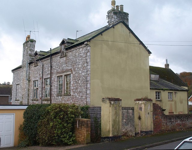
Image: © Derek Harper Taken: 9 Nov 2008
"The owner of a crumbling grade two listed building in Teignbridge faces legal action unless something is done to stop the building collapsing. The Old Vicarage in Weech Road, Dawlish, is owned by a London man and has been empty for 20 years. The property was listed in 1951 as a grade two building of special architectural and historic importance. The original house is thought to date from the 17th century and a later wing was added in 1846. It is constructed of traditional Devon cob with a slate roof, historic trusses and stable pavers. The property is a good example of a simple but historic curtilage building, and is situated close to the Dawlish Conservation Area. But now there are holes in the roof, pigeons live in the loft space, the windows are broken and part of the ground floor is missing" http://www.dawlish.com/News/Legal-threat-1673.aspx The above piece appeared in 2005; the full account of the situation then is at http://www.teignbridge.gov.uk/media/pdf/a/5/EX2005_June_13_Rep_Weech_Road_Dawlish.pdf . Little seems to have changed. According to http://www.devon.gov.uk/walk86-dawlishdiscoverywalk.pdf , "many years ago there was an idea to run a railway line around the back of Dawlish and this building was earmarked as the potential station."
Images are licensed for reuse under creativecommons.org/licenses/by-sa/2.0
Image Location
Latitude
50.581777
Longitude
-3.481322