IMAGES TAKEN NEAR TO
Ashcombe, DAWLISH, EX7 0QA
Introduction
This page details the photographs taken nearby to EX7 0QA by members of the Geograph project.
The Geograph project started in 2005 with the aim of publishing, organising and preserving representative images for every square kilometre of Great Britain, Ireland and the Isle of Man.

There are currently over 7.5m images from over14,400 individuals and you can help contribute to the project by visiting https://www.geograph.org.uk
Image Map
Images are licensed for reuse under creativecommons.org/licenses/by-sa/2.0
Notes
- Clicking on the map will re-center to the selected point.
- The higher the marker number, the further away the image location is from the centre of the postcode.
Image Listing (86 Images Found)
Images are licensed for reuse under creativecommons.org/licenses/by-sa/2.0
Image
Details
Distance
1
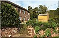
Langdon Barton
The only photo of the listed farmhouse so far seems to be Image "Farmhouse and integral cider house in cellar" https://www.historicengland.org.uk/listing/the-list/list-entry/1246026 .
Image: © Derek Harper
Taken: 5 Oct 2017
0.00 miles
2
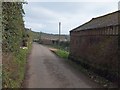
A variety of farm buildings at Langdon Barton
On the right, the nearest building is brick-built. Beyond that the construction is stone with a modern pitched roof. In the distance on the right is Dutch barn
Image: © David Smith
Taken: 7 Feb 2012
0.01 miles
3
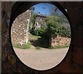
Langdon Barton
The farmhouse reversed in the traffic mirror on the barn opposite.
Image: © Derek Harper
Taken: 21 Apr 2009
0.02 miles
4
Buildings at Langdon Barton
Image: © Derek Harper
Taken: 5 Oct 2017
0.02 miles
5
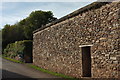
Door in wall, Langdon Barton
The building can be seen in Image
Image: © Derek Harper
Taken: 5 Oct 2017
0.02 miles
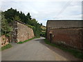
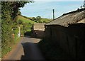
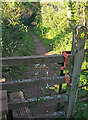
7
Farm track, Langdon Barton
Image: © Derek Harper
Taken: 6 May 2021
0.03 miles
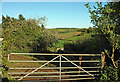
8
Footpath to Langdon
Ashcombe Footpath 4 passes a gate into a field and then goes through a gate itself, as it climbs around bends up the valley side.
Image: © Derek Harper
Taken: 6 May 2021
0.03 miles
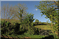
9
Stile above Langdon Barton
On Ashcombe Footpath 4. The metal gate to the right can be seen in Image
Image: © Derek Harper
Taken: 6 May 2021
0.03 miles
10
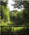
Footpath near Langdon Barton
Ashcombe Footpath 4 follows a green lane that winds down from a ridge to join the lane along the Dawlish Water valley, as shown in Image From this gate on it is used for farming activity; the section behind the camera is mostly used by badgers or foxes.
Image: © Derek Harper
Taken: 10 Aug 2012
0.03 miles