IMAGES TAKEN NEAR TO
Sweetbriar Close, DAWLISH, EX7 0JY
Introduction
This page details the photographs taken nearby to Sweetbriar Close, EX7 0JY by members of the Geograph project.
The Geograph project started in 2005 with the aim of publishing, organising and preserving representative images for every square kilometre of Great Britain, Ireland and the Isle of Man.

There are currently over 7.5m images from over14,400 individuals and you can help contribute to the project by visiting https://www.geograph.org.uk
Image Map
Images are licensed for reuse under creativecommons.org/licenses/by-sa/2.0
Notes
- Clicking on the map will re-center to the selected point.
- The higher the marker number, the further away the image location is from the centre of the postcode.
Image Listing (86 Images Found)
Images are licensed for reuse under creativecommons.org/licenses/by-sa/2.0
Image
Details
Distance
1

Public footpath on the edge of Holcombe
The path from Holcombe Down passes between these bungalows on the edge of Holcombe in Sweetbriar Lane. Presumably the path existed before the development.
Image: © David Smith
Taken: 14 Feb 2012
0.04 miles
2

North on Holcombe Road and north out of the village, Holcombe
Image: © Robin Stott
Taken: 19 Jan 2014
0.05 miles
3
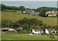
Western edge of Holcombe
At the top are houses on Sweetbriar Lane. Below are buildings at Court Farm and Manor Farm, with houses on Brook Close.
Image: © Derek Harper
Taken: 3 Sep 2023
0.06 miles
4
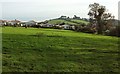
Pasture, Holcombe
Dawlish Footpath 24 crosses this meadow above the Holcombe valley, heading for the stile shown in Image onto Sweetbriar Lane.
Image: © Derek Harper
Taken: 23 Nov 2015
0.07 miles
5
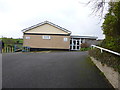
Holcombe Village Hall
The Village Hall is located at the junction of Forder Lane and Holcombe Road, opposite the Castle Inn. Looking at the weekly events it is well used by a variety of activities for all ages. It also has the benefit of a good sized car park.
Image: © John C
Taken: 20 Feb 2016
0.07 miles
6

Holcombe Road
The main street through Holcombe, just about to drop steeply into the valley, with the twin chimneys of the Castle Inn (see Image) ahead.
Image: © Derek Harper
Taken: 1 Sep 2012
0.07 miles
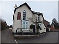
8

Castle Inn, Holcombe
Taken from the same point as Image], showing the pub at the junction of Fordans Lane and the main village street.
Image: © Derek Harper
Taken: 23 Nov 2015
0.08 miles
9
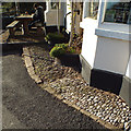
Pebbles as paving, Castle Inn, Holcombe
A change in the paving treatment usually signifies something; it isn't only decorative. Here it may be the property boundary, or the pebbles may merely be to deter people from peering through the window.
Image: © Robin Stott
Taken: 19 Jan 2014
0.08 miles
10
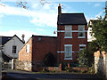
Holmeleigh, Fordens Lane, Holcombe
A similar property behind this faces on to Holcombe Road.
Image: © Robin Stott
Taken: 19 Jan 2014
0.08 miles