IMAGES TAKEN NEAR TO
Elm Grove Road, DAWLISH, EX7 0DD
Introduction
This page details the photographs taken nearby to Elm Grove Road, EX7 0DD by members of the Geograph project.
The Geograph project started in 2005 with the aim of publishing, organising and preserving representative images for every square kilometre of Great Britain, Ireland and the Isle of Man.

There are currently over 7.5m images from over14,400 individuals and you can help contribute to the project by visiting https://www.geograph.org.uk
Image Map
Images are licensed for reuse under creativecommons.org/licenses/by-sa/2.0
Notes
- Clicking on the map will re-center to the selected point.
- The higher the marker number, the further away the image location is from the centre of the postcode.
Image Listing (231 Images Found)
Images are licensed for reuse under creativecommons.org/licenses/by-sa/2.0
Image
Details
Distance
2
Oak Park Road, Dawlish
One of the 19th century villas along the east side of this road.
Image: © Stephen Craven
Taken: 27 Oct 2019
0.05 miles
3
Oakwood Court College, Dawlish
The college occupies one of the 19th century villas along the east side of Oak Park Road. It offers vocational courses for students with learning or physical disabilities.
Image: © Stephen Craven
Taken: 27 Oct 2019
0.08 miles
4
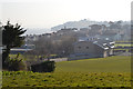
North Dawlish from the former Pitch and Putt, Sandy Lane
Dawlish Leisure Centre is in the middle distance with Dawlish Community College beyond it. Along the coast the Parson and Clerk, the sandstone formation below Hole Head, is grey in the distance. At this time of year, mid-March, the Pitch and Putt looks abandoned and overgrown but we'll see later if it's brought into use again.
Image: © Robin Stott
Taken: 14 Mar 2016
0.10 miles
5

Old Gatehouse Road, Dawlish
Stanmore Rise to the left is a short dead-end residential street.
Image: © Stephen Craven
Taken: 27 Oct 2019
0.11 miles
6

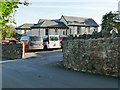
Dawlish Community College
The door at this end is the student entrance.
Image: © David Smith
Taken: 23 Jan 2012
0.11 miles
7
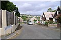
Old Gatehouse Road
A single-track road, looking downhill from the right-angle bend.
Image: © Stephen Craven
Taken: 26 Sep 2010
0.11 miles
8
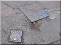
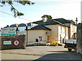
Service boxes
The nearer of these two on East Cliff Road has the inscription "DUC SVB" which I interpret as "Dawlish Urban Council sluice valve box". DUC no longer exists (probably swallowed up in the 1974 reforms?). The other is a more standard Stanton & Staveley sewer manhole cover (c.1980-2000?).
Image: © Stephen Craven
Taken: 4 Aug 2011
0.12 miles
9
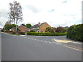
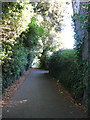
Elm Grove Drive, Dawlish
Elm Grove was the name of a large 19th century private house which stood behind the trees to the left of the photo. It was demolished in the late 20th century and the land around it used for housing.
Image: © Stephen Craven
Taken: 27 Oct 2019
0.13 miles
10
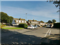
East Cliff Close, Dawlish
A steep cul-de-sac with, from the top, a view across to the Henty Avenue residential area in the opposite corner of the square.
Image: © Robin Stott
Taken: 19 Jul 2009
0.13 miles