IMAGES TAKEN NEAR TO
Lower Ashton, EXETER, EX6 7QN
Introduction
This page details the photographs taken nearby to EX6 7QN by members of the Geograph project.
The Geograph project started in 2005 with the aim of publishing, organising and preserving representative images for every square kilometre of Great Britain, Ireland and the Isle of Man.

There are currently over 7.5m images from over14,400 individuals and you can help contribute to the project by visiting https://www.geograph.org.uk
Image Map
Images are licensed for reuse under creativecommons.org/licenses/by-sa/2.0
Notes
- Clicking on the map will re-center to the selected point.
- The higher the marker number, the further away the image location is from the centre of the postcode.
Image Listing (26 Images Found)
Images are licensed for reuse under creativecommons.org/licenses/by-sa/2.0
Image
Details
Distance
1
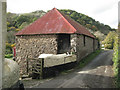
Stone barn with kitten, Lower Ashton
Part of Blatchford Farm. The barn was full of the sound of pigeons or poultry and the kitten was very shy.
Image: © Robin Stott
Taken: 30 Oct 2010
0.01 miles
2
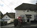
Post Office Stores, Lower Ashton
Postbox number EX6 191. Forge Cottage on the left. The lane leads eventually to Doddiscombsleigh Image
Image: © Robin Stott
Taken: 30 Oct 2010
0.04 miles
3

Lower Ashton, 2000
The Manor Inn is on the right. The nearer of the two thatched cottages left of centre is Forge Cottage, which is "on a corner site in the centre of Lower Ashton and makes a crucial contribution to a group including Spara Bridge, the Post Office and Blatchford Farmhouse" https://www.historicengland.org.uk/listing/the-list/list-entry/1097821 . Rising behind it is the post office (former, that is) https://www.historicengland.org.uk/listing/the-list/list-entry/1097820 . And in the foreground is our old Volvo.
Image: © Derek Harper
Taken: 1 May 2000
0.04 miles
4

Manor Inn and a meadow, Lower Ashton
The pub's walls have been stripped of climbing plants since 2005 Image
Image: © Robin Stott
Taken: 30 Oct 2010
0.04 miles
5
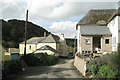
Dwellings, Lower Ashton
Blatchford, centre; Jerston Cottage being extended, right. Hill Copse beyond drops steeply to the valley of the river Teign. The lane leads eventually to Doddiscombsleigh Image
Image: © Robin Stott
Taken: 30 Oct 2010
0.06 miles
6

Hillside garden, 'Brends', Lower Ashton
Image: © Robin Stott
Taken: 30 Oct 2010
0.06 miles

8

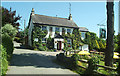
Ashton station (site/remnants)
View northward, towards Christow and Exeter: ex-GWR Teign Valley line (Exeter - Christow - Heathfield - Newton Abbot). The station was closed on cessation of the passenger service 9/6/58, goods 2/3/59. The houses and garden have obviously been built more recently, incorporating some of the station.
Image: © Ben Brooksbank
Taken: 29 Apr 2000
0.08 miles
9
Manor Inn, Ashton
The village pub at Lower Ashton, just off the Teign Valley Road.
Image: © Mike Crowe
Taken: 8 Jun 2005
0.09 miles
10

Oak at Lower Ashton
This venerable oak is in the middle of a meadow beside Image
Image: © Derek Harper
Taken: 3 Jul 2009
0.09 miles