IMAGES TAKEN NEAR TO
Sweet Chestnut, EXETER, EX5 7FQ
Introduction
This page details the photographs taken nearby to Sweet Chestnut, EX5 7FQ by members of the Geograph project.
The Geograph project started in 2005 with the aim of publishing, organising and preserving representative images for every square kilometre of Great Britain, Ireland and the Isle of Man.

There are currently over 7.5m images from over14,400 individuals and you can help contribute to the project by visiting https://www.geograph.org.uk
Image Map
Images are licensed for reuse under creativecommons.org/licenses/by-sa/2.0
Notes
- Clicking on the map will re-center to the selected point.
- The higher the marker number, the further away the image location is from the centre of the postcode.
Image Listing (27 Images Found)
Images are licensed for reuse under creativecommons.org/licenses/by-sa/2.0
Image
Details
Distance
1
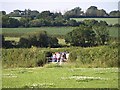
Balloon-watchers near Jack-in-the-Green
Watching Image take off from a gate on the lane between Jack-in-the-Green and Image Behind are fields either side of the Cranny Brook.
Image: © Derek Harper
Taken: 1 Jul 2009
0.05 miles
2
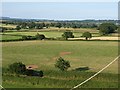
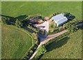
Fields near Crannaford
In the foreground is the lane between Jack-in-the-Green and Crannaford. Beyond, field stretch away across almost level land towards Southbrook. Taken from a hot air balloon, one of whose ropes dangles in front of the camera.
Image: © Derek Harper
Taken: 1 Jul 2009
0.05 miles
4
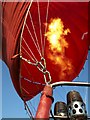
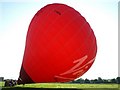
Flame, hot air balloon
Heating the air in the envelope prior to take-off of Image How many people get their hair singed by these things?
Image: © Derek Harper
Taken: 1 Jul 2009
0.13 miles
5
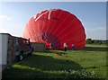
Hot air balloon, Jack-in-the-Green
The envelope shown inflating in Image starts to lift away from the ground. Time to get in the basket.
Image: © Derek Harper
Taken: 1 Jul 2009
0.13 miles
6
Hot air balloon, Jack-in-the-Green
A hot air balloon inflates in the meadow shown in Image
Image: © Derek Harper
Taken: 1 Jul 2009
0.13 miles
7
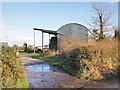
Lane junction near Crannaford
The upper arms of the Y form the lane between Jack-in-the-Green and Crannaford. The barn appears in Image Seen from a hot air balloon.
Image: © Derek Harper
Taken: 1 Jul 2009
0.14 miles
9

Old Boundary Marker by the B3174, Jack-in-the-Green, Rockbeare Parish
Parish Boundary Marker by the B3174 (was A30), in parish of Rockbeare (East Devon District), 100m East of Murco garage, just East of the junction at Stone Cottage, at back of wide grass verge in the new hedge.
Surveyed
Milestone Society National ID: DV_HNEX09pb
Image: © Alan Rosevear
Taken: 3 Apr 2013
0.15 miles
10
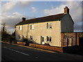
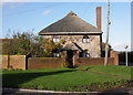
Cottages, on the old A30, near Rockbeare
Image: © Roger Cornfoot
Taken: 20 Nov 2009
0.16 miles