IMAGES TAKEN NEAR TO
Brampford Speke, EXETER, EX5 5HJ
Introduction
This page details the photographs taken nearby to EX5 5HJ by members of the Geograph project.
The Geograph project started in 2005 with the aim of publishing, organising and preserving representative images for every square kilometre of Great Britain, Ireland and the Isle of Man.

There are currently over 7.5m images from over14,400 individuals and you can help contribute to the project by visiting https://www.geograph.org.uk
Image Map
Images are licensed for reuse under creativecommons.org/licenses/by-sa/2.0
Notes
- Clicking on the map will re-center to the selected point.
- The higher the marker number, the further away the image location is from the centre of the postcode.
Image Listing (40 Images Found)
Images are licensed for reuse under creativecommons.org/licenses/by-sa/2.0
Image
Details
Distance
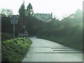
2
Lane north of Brampford Speke
The lane towards Thorverton rounds a bend past an oak newly in leaf to run just above the River Exe.
Image: © Derek Harper
Taken: 4 May 2010
0.10 miles
3
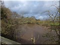
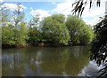
River Exe north of Brampford Speke
The flow in the river is high after considerable rain
Image: © David Smith
Taken: 14 Feb 2013
0.11 miles
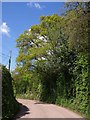
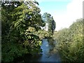
4
River Exe
The Exe (flowing to the right) a little upstream from Brampford Speke, seen from the lane shown in Image A young wood is establishing itself on the far bank, which is on the inside of a meander.
Image: © Derek Harper
Taken: 4 May 2010
0.11 miles

6

East Devon : Red Rock Road
Looking along Red Rock Road which heads through the countryside.
Image: © Lewis Clarke
Taken: 21 Jun 2015
0.12 miles
7

Red Rock
Many junctions of Devon country roads are marked with a sign indicating the name of the locality followed by a cross. Red Rock is an exception, as being marked by that name. The road beyond leads into the next gridsquare.
Image: © David Smith
Taken: 21 Feb 2011
0.12 miles
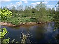
8
River Exe
The river, just upstream from Brampford Speke, and flowing to the right. This is from the termination of Brampford Speke Footpath 15, which runs for about 80 metres from the lane and ends here on the bank. Was there once a ford? Looks like there might be leeches - the languidly tropical air is enhanced by the bamboo on the right, although those are very cool temperate willows on the far bank, just bursting into leaf. If you need to cross, there is a footbridge from the village.
Image: © Derek Harper
Taken: 4 May 2010
0.14 miles
9
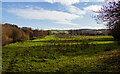
Field near the River Exe at Brampford Speke
Image: © Roger Jones
Taken: 28 Nov 2021
0.14 miles
10
River Exe from Brampford Speke footbridge
Image: © David Smith
Taken: 27 Oct 2023
0.16 miles