IMAGES TAKEN NEAR TO
The Village, EXETER, EX5 5BU
Introduction
This page details the photographs taken nearby to The Village, EX5 5BU by members of the Geograph project.
The Geograph project started in 2005 with the aim of publishing, organising and preserving representative images for every square kilometre of Great Britain, Ireland and the Isle of Man.

There are currently over 7.5m images from over14,400 individuals and you can help contribute to the project by visiting https://www.geograph.org.uk
Image Map
Images are licensed for reuse under creativecommons.org/licenses/by-sa/2.0
Notes
- Clicking on the map will re-center to the selected point.
- The higher the marker number, the further away the image location is from the centre of the postcode.
Image Listing (128 Images Found)
Images are licensed for reuse under creativecommons.org/licenses/by-sa/2.0
Image
Details
Distance
1
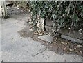
Bridge Marker on the A337 in Newton St Cyres
County Bridge Marker sunk in the tarmac of the pavement beside the front gate of No.3 on the north side of the A337 Main Road, 100 metres west of Shuttern Bridge, Shuttern Brook. Newton St Cyres parish. The bridge was built at County expense in 1831, replacing an old packbridge and ford, and the stone marks the extent of roadway adjoining the bridge that the County was obliged to maintain.
Milestone Society National ID: DV_EXBS04br
Image: © A Rosevear
Taken: 18 Feb 2011
0.01 miles
3
Cottages by the village green, Newton St Cyres
Image: © David Gearing
Taken: 14 Apr 2015
0.02 miles
4
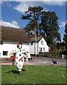
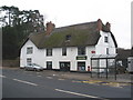
Scarecrow, Newton St Cyres
Newton St Cyres' scarecrow festival is in full swing, and this participant is on the village green by the junction of West Town Road and the A377, in front of Shuttern Close. The thatched cottage is the C18 Shapland's Cottage http://www.imagesofengland.org.uk/Details/Default.aspx?id=96388&mode=adv whose east end had to be rebuilt when the main road was widened in 1965.
Image: © Derek Harper
Taken: 4 May 2010
0.02 miles
5
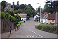
A377 through Newton St Cyres
The church is unusually dedicated to St. Cyriac and his mother St. Julitta.
Image: © J.Hannan-Briggs
Taken: 20 Jul 2017
0.02 miles
6
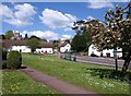
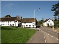
Green, Newton St Cyres
Looking in the other direction to Image, with the two bus stops facing each other across the A377, and cottages at the end of West Town Road, above which rises Image
Image: © Derek Harper
Taken: 4 May 2010
0.03 miles
7
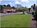
Green, Newton St Cyres
On the left, across the A377, is Image On the right, by the junction with Pump Street, is the (probably) C18 thatched cottage no 33 http://www.imagesofengland.org.uk/Details/Default.aspx?id=96390&mode=adv . Trees are in blossom.
Image: © Derek Harper
Taken: 4 May 2010
0.03 miles

9
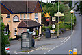
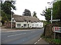
Newton St Cyres : The A377
Looking along the road as it passes The Crown and Sceptre.
Image: © Lewis Clarke
Taken: 30 Jul 2016
0.03 miles