IMAGES TAKEN NEAR TO
High Street, EXETER, EX5 4NJ
Introduction
This page details the photographs taken nearby to High Street, EX5 4NJ by members of the Geograph project.
The Geograph project started in 2005 with the aim of publishing, organising and preserving representative images for every square kilometre of Great Britain, Ireland and the Isle of Man.

There are currently over 7.5m images from over14,400 individuals and you can help contribute to the project by visiting https://www.geograph.org.uk
Image Map
Images are licensed for reuse under creativecommons.org/licenses/by-sa/2.0
Notes
- Clicking on the map will re-center to the selected point.
- The higher the marker number, the further away the image location is from the centre of the postcode.
Image Listing (144 Images Found)
Images are licensed for reuse under creativecommons.org/licenses/by-sa/2.0
Image
Details
Distance
1

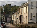
Bradninch: junction of High Street with Peter Street
The town - with buildings largely dating from the nineteenth century - is built on quite hilly topography. High Street runs down to West End Road and the way to Silverton
Image: © Martin Bodman
Taken: 15 Jun 2018
0.01 miles
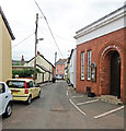
2
High Street, Bradninch
Looking down the steep little High Street, with a raised pavement. The smoking chimney at the foot of the hill belongs to the White Lion pub.
Image: © Derek Harper
Taken: 20 Oct 2010
0.01 miles
3

Bradninch : High Street
A parade takes place to mark 12th Night in Bradninch.
Image: © Lewis Clarke
Taken: 6 Jan 2022
0.01 miles
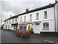
4

Bradninch: Fore Street
The village centre, with the Castle Inn, Fore Street, on the left. An old coaching inn, it included a small brewery in the 19th century. Bradninch was once on the great west road from Bristol to Exeter but was largely bypassed by long-distance traffic following the opening of the Cullompton turnpike in circa 1820, which ran in the valley via Broadclyst. This road, later designated the A38, was itself superseded by the M5 Motorway in 1977
Image: © Martin Bodman
Taken: 17 Aug 2005
0.01 miles
5

Beacon Road, Bradninch
A reverse view of the street shown in Image The pinkish house is at the corner of Peter Street.
Image: © Derek Harper
Taken: 19 Mar 2011
0.01 miles
6
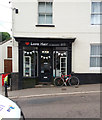
Bradninch: Love Hair
In the High Street. On the left a BT engineer is at work on the corner of Back Street. Beyond him is a building known as 'The Old Bakery'
Image: © Martin Bodman
Taken: 15 Jun 2018
0.02 miles
8
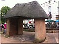
Shelter on Fore Street, Bradninch
Thatched shelter at junction of Fore Street, High Street and Millway in Bradninch, Devon
Image: © A J Paxton
Taken: 1 Jun 2014
0.03 miles

10
Bradninch: Peter Street
View towards the High Street, with the Gospel Hall on the right. The opposite view to Image]
Image: © Martin Bodman
Taken: 15 Jun 2018
0.03 miles