IMAGES TAKEN NEAR TO
River Close, EXETER, EX5 4AF
Introduction
This page details the photographs taken nearby to River Close, EX5 4AF by members of the Geograph project.
The Geograph project started in 2005 with the aim of publishing, organising and preserving representative images for every square kilometre of Great Britain, Ireland and the Isle of Man.

There are currently over 7.5m images from over14,400 individuals and you can help contribute to the project by visiting https://www.geograph.org.uk
Image Map
Images are licensed for reuse under creativecommons.org/licenses/by-sa/2.0
Notes
- Clicking on the map will re-center to the selected point.
- The higher the marker number, the further away the image location is from the centre of the postcode.
Image Listing (91 Images Found)
Images are licensed for reuse under creativecommons.org/licenses/by-sa/2.0
Image
Details
Distance
1
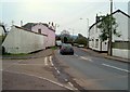
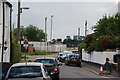
High Street, Stoke Canon
The A396 winds through the village, past the junction with Honors Farm, a modern development of detached houses named after the pink C19 house on the left, The Honors http://list.english-heritage.org.uk/resultsingle.aspx?uid=1333983&searchtype=mapsearch , though I don't think there was a farm called "Honors Farm". (The high wall is listed together with the house.)
Image: © Derek Harper
Taken: 16 Mar 2006
0.08 miles
2

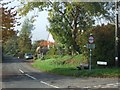
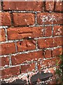
Old Milestone by the A396, Stoke Canon Parish
Carved stone post by the A396, in parish of STOKE CANON (EAST DEVON District), High Street, 100m North of bridge over River Culm, in pillar of wall between two driveways, on West side of road. Exeter tombstone, erected by the Exeter turnpike trust in the 18th century.
Inscription reads:-
V
MILES
FROM
EXON
Milestone Society National ID: DV_EXTT05.
Image: © Alan Rosevear
Taken: 16 Apr 2011
0.08 miles

4

Stoke Canon: by Stoke Canon Crossing
A Virgin Voyager heads south towards Exeter
Image: © Martin Bodman
Taken: 23 Oct 2007
0.10 miles
6
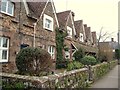
Myrtle Cottages, Stoke Canon
A terrace of six gabled C19 cottages on the A396.
Image: © Derek Harper
Taken: 16 Mar 2006
0.10 miles
7
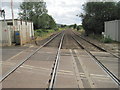
Stoke Canon 1st railway station (site), Devon
Opened in 1860 by the Bristol & Exeter Railway, later part of the Great Western Railway, this station closed in 1895 when it was replaced by a new station around 400m further south.
View south west towards the later station and Exeter St. Davids. The southbound platform was to the left of the track. The northbound platform was behind the camera position.
Image: © Nigel Thompson
Taken: 11 Jul 2015
0.11 miles
8
Chestnut Crescent and a closed level crossing
A train is due on the main line to Exeter.
Image: © Bill Boaden
Taken: 27 Jun 2014
0.11 miles
9
Cut Mark: Stoke Canon, Signal Box
CUT MARK: SB SE SIDE RLY SW FACE S ANG (ODN 22.488m, AGL 0.8m).
Image: © Meg Hepworth
Taken: 21 Aug 2020
0.12 miles
10
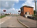
Level crossing, Stoke Canon
Across the road to Oakhay Barton, and seen from the junction with Chestnut Crescent. The gates are down and the red lights are flashing, as a Paddington-Penzance service is about to pass. The brick building on the right is the "last surviving Bristol and Exeter Signal Box", dating from 1874 http://www.britishlistedbuildings.co.uk/en-86133-stoke-canon-crossing-box-stoke-canon .
Image: © Derek Harper
Taken: 23 Jul 2010
0.12 miles