IMAGES TAKEN NEAR TO
Budlake, EXETER, EX5 3JW
Introduction
This page details the photographs taken nearby to EX5 3JW by members of the Geograph project.
The Geograph project started in 2005 with the aim of publishing, organising and preserving representative images for every square kilometre of Great Britain, Ireland and the Isle of Man.

There are currently over 7.5m images from over14,400 individuals and you can help contribute to the project by visiting https://www.geograph.org.uk
Image Map
Images are licensed for reuse under creativecommons.org/licenses/by-sa/2.0
Notes
- Clicking on the map will re-center to the selected point.
- The higher the marker number, the further away the image location is from the centre of the postcode.
Image Listing (29 Images Found)
Images are licensed for reuse under creativecommons.org/licenses/by-sa/2.0
Image
Details
Distance
1
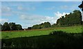
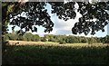
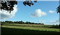
Meadow, Budlake
From a route with public access in between the M5 and the B3181. The distant Fords Court Cottages are in Image
Image: © Derek Harper
Taken: 2 Sep 2015
0.09 miles
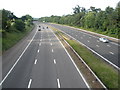
3
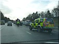
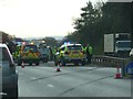
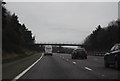
East Devon : The M5 Motorway
Traffic officers and police on the motorway where a vehicle had spilled nails onto the road.
Image: © Lewis Clarke
Taken: 26 Nov 2012
0.16 miles
4
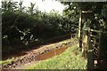
Puddle, track and signpost, Sprydon Walk
The field access track leads from the B3151. The footpath sign indicates the direction of the Sprydon Walk http://www.nationaltrust.org.uk/killerton/things-to-see-and-do/view-page/item470090/ .
Image: © Derek Harper
Taken: 2 Sep 2015
0.17 miles
5
East Devon : The M5 Motorway
Traffic officers and police on the motorway where a vehicle had spilled nails onto the road.
Image: © Lewis Clarke
Taken: 26 Nov 2012
0.18 miles
6
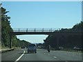
Motorway bridge for track near Budlake
This bridge carries a farm track
Image: © David Smith
Taken: 30 Aug 2010
0.19 miles
7
Field, Sprydoncote
A glimpse of a corner of the C18 house, listed as "Sprydon House" http://list.historicengland.org.uk/resultsingle.aspx?uid=1098354&searchtype=mapsearch , across a crop of maize and other fields.
Image: © Derek Harper
Taken: 2 Sep 2015
0.19 miles
8
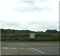
Approaching the B3181
Right to Exeter, left to Cullompton.
Image: © John C
Taken: 22 Jul 2019
0.19 miles
10
Field by the B3151
On the other side from Image] of the line of trees along which the route with public access runs. You can make out a signpost and a bus shelter right of centre on the B3151. These are by the T junction with the road past Killerton, which runs along the right side of the field.
Image: © Derek Harper
Taken: 2 Sep 2015
0.20 miles