IMAGES TAKEN NEAR TO
Broadclyst, EXETER, EX5 3DS
Introduction
This page details the photographs taken nearby to EX5 3DS by members of the Geograph project.
The Geograph project started in 2005 with the aim of publishing, organising and preserving representative images for every square kilometre of Great Britain, Ireland and the Isle of Man.

There are currently over 7.5m images from over14,400 individuals and you can help contribute to the project by visiting https://www.geograph.org.uk
Image Map
Images are licensed for reuse under creativecommons.org/licenses/by-sa/2.0
Notes
- Clicking on the map will re-center to the selected point.
- The higher the marker number, the further away the image location is from the centre of the postcode.
Image Listing (16 Images Found)
Images are licensed for reuse under creativecommons.org/licenses/by-sa/2.0
Image
Details
Distance
1
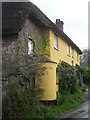
3 Hollis Head
Owned by the National Trust and painted in the yellow shade that is standard on the Killerton Estate. At the time, the near half of the house was a holiday cottage, but it no longer (2012) features in the Trust's list of holiday properties.
Image: © Christopher Hilton
Taken: 23 Apr 2005
0.00 miles
3
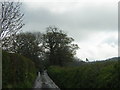
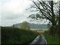
Lane to Ashclyst Forest at Hollis Head cottages
Image: © Rob Purvis
Taken: 12 May 2012
0.03 miles
4
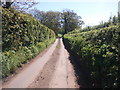
Hollis Head: looking up the lane from no.3
On either side of the lane, typical thick Devon hedgerows.
Image: © Christopher Hilton
Taken: 23 Apr 2005
0.04 miles
5
Hollis Head: looking down the lane from no.3
Image: © Christopher Hilton
Taken: 23 Apr 2005
0.05 miles
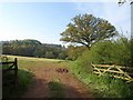
6
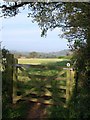
Gate near Churchill Oak
A National Trust bridleway sign is on this gate beside the lane between Rewes Cross and Budlake.
Image: © Derek Harper
Taken: 13 May 2010
0.06 miles
7
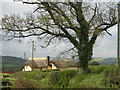
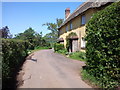
Hollis Head: view downhill to National Trust cottages
The buildings seen here are a set of three adjoining National Trust cottages, painted in the yellow that is standard on the Trust's Killerton estate.
Image: © Christopher Hilton
Taken: 23 Apr 2005
0.07 miles
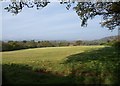
9
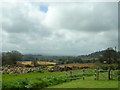
Field near Churchill Oak
On the far side of the valley to which this field descends is Sprydon Plantation, part of Ashclyst Forest. Oaks newly in leaf along the field boundary.
Image: © Derek Harper
Taken: 13 May 2010
0.08 miles
10
Field near Hollis Head
Looking over Image Behind the field boundary on the right is the lane past Hollis Head to Budlake. The large field slopes down to the valley shown in Image
Image: © Derek Harper
Taken: 13 May 2010
0.08 miles