IMAGES TAKEN NEAR TO
Rockbeare, EXETER, EX5 2LU
Introduction
This page details the photographs taken nearby to EX5 2LU by members of the Geograph project.
The Geograph project started in 2005 with the aim of publishing, organising and preserving representative images for every square kilometre of Great Britain, Ireland and the Isle of Man.

There are currently over 7.5m images from over14,400 individuals and you can help contribute to the project by visiting https://www.geograph.org.uk
Image Map
Images are licensed for reuse under creativecommons.org/licenses/by-sa/2.0
Notes
- Clicking on the map will re-center to the selected point.
- The higher the marker number, the further away the image location is from the centre of the postcode.
Image Listing (16 Images Found)
Images are licensed for reuse under creativecommons.org/licenses/by-sa/2.0
Image
Details
Distance
1
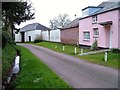
Rag Lane, Westcott
Another view along the charming row of buildings shown in Image
Image: © Derek Harper
Taken: 29 Mar 2006
0.02 miles
2
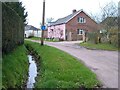
Rag Lane, Westcott
The reverse of Image, with the pink Coach House and farm buildings at Westcott Farm on the right, and a ditch on the left. The hipped roof of an C18 former threshing barn http://list.english-heritage.org.uk/resultsingle.aspx?uid=1141390&searchtype=mapsearch can be seen on the extreme right.
Image: © Derek Harper
Taken: 29 Mar 2006
0.03 miles
3
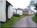
Westcott
The outbuildings of Westcott Farm, facing onto Rag Lane, a few yards from the busy A30. Looking south.
Image: © Derek Harper
Taken: 29 Mar 2006
0.03 miles
4
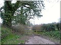
Closed lane, Westcott
Truncated by the A30 dual carriageway which was completed in 1999, Rag Lane used to link Westcott with Rockbeare House. A fence now bars progress.
Image: © Derek Harper
Taken: 29 Mar 2006
0.03 miles
5
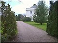
Westcott House
A glimpse of the C18 / C19 country house described at http://list.english-heritage.org.uk/resultsingle.aspx?uid=1203853&searchtype=mapsearch , from Rag Lane (shown in Image).
Image: © Derek Harper
Taken: 29 Mar 2006
0.04 miles
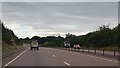
6
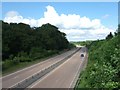
Looking east along the A30 at Westcott
On the left of the road there is a short stretch of wall. It shields the main road from the lights of traffic on a farm track which passes through the covert and at this point is immediately adjacent to the A30
Image: © David Smith
Taken: 6 Jun 2010
0.12 miles
7
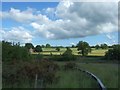
Looking south across the fields west of Westcott
Image: © David Smith
Taken: 6 Jun 2010
0.13 miles
8
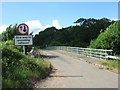
Bridge over A30 near Westcott
Both ends of the bridge have "Give Way" signs.
Image: © David Smith
Taken: 6 Jun 2010
0.17 miles
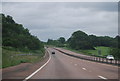
10
A30 eastbound towards Marsh Green
Light traffic at 9am.
Image: © Julian P Guffogg
Taken: 12 Aug 2013
0.19 miles