IMAGES TAKEN NEAR TO
Village Way, EXETER, EX5 2BX
Introduction
This page details the photographs taken nearby to Village Way, EX5 2BX by members of the Geograph project.
The Geograph project started in 2005 with the aim of publishing, organising and preserving representative images for every square kilometre of Great Britain, Ireland and the Isle of Man.

There are currently over 7.5m images from over14,400 individuals and you can help contribute to the project by visiting https://www.geograph.org.uk
Image Map
Images are licensed for reuse under creativecommons.org/licenses/by-sa/2.0
Notes
- Clicking on the map will re-center to the selected point.
- The higher the marker number, the further away the image location is from the centre of the postcode.
Image Listing (49 Images Found)
Images are licensed for reuse under creativecommons.org/licenses/by-sa/2.0
Image
Details
Distance

2

The road drops past the Aylesbeare Inn
Image: © Sarah Charlesworth
Taken: 15 Dec 2008
0.04 miles

4
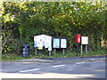
Village notices
A lot takes place in this village and surrounding area as the boards will tell you.
You can even post a letter or deposit your litter.
Image: © Anthony Vosper
Taken: 24 Oct 2010
0.04 miles
5

The Aylesbeare Inn
The inn is at a road junction in the centre of the village
Image: © David Smith
Taken: 1 Aug 2011
0.04 miles
6
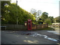
The village telephone Box
Situated at Church Close.
Image: © Anthony Vosper
Taken: 24 Oct 2010
0.06 miles
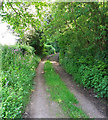
7
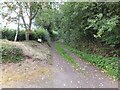
Blind Lane, Aylesbeare
Users of the lane are greeted with a succession of signs. First: Unmetalled Road; then: Unsuitable for Vehicles; then: County Road. It is a rough track, with an eroded surface, leading to woods on the east of the village.
Image: © David Smith
Taken: 1 Aug 2011
0.07 miles
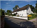
9
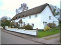
Thatched cottages, Aylesbeare
A severely over-exposed image, but submitted as no one else has taken this trio of listed cottages, described as a pair in the description at http://list.english-heritage.org.uk/resultsingle.aspx?uid=1141431&searchtype=mapsearch . Truants, formerly the larger part nearer the camera, has since been sub-divided.
Image: © Derek Harper
Taken: 29 Mar 2006
0.07 miles
10
Aylesbeare: Blind Lane
The lane runs east of the village to Topshays Farm on the lane to Broad Oak
Image: © Martin Bodman
Taken: 21 May 2018
0.07 miles