IMAGES TAKEN NEAR TO
Whitestone, EXETER, EX4 2JX
Introduction
This page details the photographs taken nearby to EX4 2JX by members of the Geograph project.
The Geograph project started in 2005 with the aim of publishing, organising and preserving representative images for every square kilometre of Great Britain, Ireland and the Isle of Man.

There are currently over 7.5m images from over14,400 individuals and you can help contribute to the project by visiting https://www.geograph.org.uk
Image Map
Images are licensed for reuse under creativecommons.org/licenses/by-sa/2.0
Notes
- Clicking on the map will re-center to the selected point.
- The higher the marker number, the further away the image location is from the centre of the postcode.
Image Listing (11 Images Found)
Images are licensed for reuse under creativecommons.org/licenses/by-sa/2.0
Image
Details
Distance
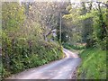
1
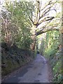
Church Lane, Whitestone
Further down the sunken lane shown in Image], and with too much contrast between shady depths and sunlit areas above. Image is just around the corner.
Image: © Derek Harper
Taken: 28 Apr 2006
0.12 miles
2
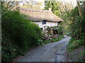
Church Bridge Cottage, Whitestone
In the valley of the Nadder Brook, on Church Lane midway between the main road village and the church hamlet parts of Whitestone. The cottage is described at http://list.english-heritage.org.uk/resultsingle.aspx?uid=1287616&searchtype=mapsearch .
Image: © Derek Harper
Taken: 28 Apr 2006
0.14 miles
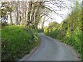
3
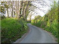
Church Lane, Whitestone
The lane climbs away steeply from the Nadder Brook towards the church barton part of the village.
Image: © Derek Harper
Taken: 28 Apr 2006
0.14 miles
4

Parallel lanes, Whitestone
The entrance track for Oak Tree Farm very gradually veers away from Church Lane, starting a steep drop to the right, as shown in Image] which looks up it.
Image: © Derek Harper
Taken: 28 Apr 2006
0.14 miles
5
Church Lane, Whitestone
Climbing away from the Nadder valley and from Image; the junction shown in Image] is at the top of the hill.
Image: © Derek Harper
Taken: 28 Apr 2006
0.14 miles
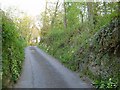
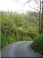
6
Church Lane, Whitestone
Dropping steeply to the foot of the Nadder Brook valley. Image can just about be discerned through the foliage.
Image: © Derek Harper
Taken: 28 Apr 2006
0.14 miles
7
Church Lane, Whitestone
Looking up the hill that Image] (taken a little behind the camera) looks down.
Image: © Derek Harper
Taken: 28 Apr 2006
0.17 miles
8
Church Lane, Whitestone
A reverse view of Image
Image: © Derek Harper
Taken: 28 Apr 2006
0.17 miles
9
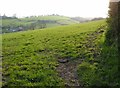
Field at Whitestone
A view from Church Lane south of Farm Barton. The backdrop is the Nadder Brook valley, with Norway and Oak Tree Farms.
Image: © Derek Harper
Taken: 28 Apr 2006
0.19 miles
10
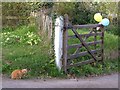
Excluded
Probably voluntarily, rather than face all those kids.
Image: © Derek Harper
Taken: 28 Apr 2006
0.20 miles