IMAGES TAKEN NEAR TO
Stoke, BIDEFORD, EX39 6DU
Introduction
This page details the photographs taken nearby to Stoke, EX39 6DU by members of the Geograph project.
The Geograph project started in 2005 with the aim of publishing, organising and preserving representative images for every square kilometre of Great Britain, Ireland and the Isle of Man.

There are currently over 7.5m images from over14,400 individuals and you can help contribute to the project by visiting https://www.geograph.org.uk
Image Map (Loading...)


Getting Data...Please wait
Leaflet Map data © OpenStreetMap
Images are licensed for reuse under creativecommons.org/licenses/by-sa/2.0
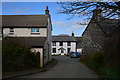
Notes
- Clicking on the map will re-center to the selected point.
- The higher the marker number, the further away the image location is from the centre of the postcode.
Image Listing (156 Images Found)
Images are licensed for reuse under creativecommons.org/licenses/by-sa/2.0
Image
Details
Distance
1

Stoke : St Nectan's Church
The lychgate is C16 or C17 wall with alterations of C18 and C19.
Image: © Lewis Clarke
Taken: 5 Apr 2016
0.00 miles
2
Stoke : Village Road
A small road heading through the village.
Image: © Lewis Clarke
Taken: 5 Apr 2016
0.01 miles
3

Stoke : Public Toilet
The urinal in the men's toilet in the hamlet of Stoke.
Image: © Lewis Clarke
Taken: 5 Apr 2016
0.01 miles
4
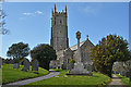
Stoke : St Nectan's Church
The current building, believed to date from 1360, replaced the earlier church on the site, of which only the font still remains and is thought to date from 1170.
Image: © Lewis Clarke
Taken: 5 Apr 2016
0.01 miles
5

Stoke : Public Toilet
The public toilet besides the church in Stoke.
Image: © Lewis Clarke
Taken: 5 Apr 2016
0.01 miles
6

Stoke
The hamlet containing the parish church of Hartland - St Nectan's - is two kilometres west of Hartland itself, but that is insignificant compared to size of this large parish - the largest in Devon ,and one of the UK's biggest.
Image: © Derek Harper
Taken: 24 Jul 2007
0.01 miles
7
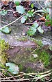
Ordnance Survey Rivet
This OS rivet can be found on the NW angle of St Nectan's House. It marks a point 81.857m above mean sea level.
Image: © Adrian Dust
Taken: 22 Jan 2018
0.01 miles
8
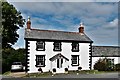
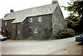
Stoke: House and annexe in the church close
Image: © Michael Garlick
Taken: 27 Sep 2018
0.01 miles
9
Church House, Stoke, Hartland
Probably dates from about 1500 https://historicengland.org.uk/listing/the-list/list-entry/1146627
Image: © Jonathan Thacker
Taken: 29 Jul 1993
0.01 miles
10

Cottages at Stoke
These cottages are opposite those shown in Image The lane between them leads (impassably for cars) to Wargery and Docton Mill.
Image: © Derek Harper
Taken: 24 Jul 2007
0.02 miles