
IMAGES TAKEN NEAR TO
Weare Giffard, BIDEFORD, EX39 5JD
Introduction
This page details the photographs taken nearby to EX39 5JD by members of the Geograph project.
The Geograph project started in 2005 with the aim of publishing, organising and preserving representative images for every square kilometre of Great Britain, Ireland and the Isle of Man.

There are currently over 7.5m images from over14,400 individuals and you can help contribute to the project by visiting https://www.geograph.org.uk
Image Map
Images are licensed for reuse under creativecommons.org/licenses/by-sa/2.0
Notes
- Clicking on the map will re-center to the selected point.
- The higher the marker number, the further away the image location is from the centre of the postcode.
Image Listing (32 Images Found)
Images are licensed for reuse under creativecommons.org/licenses/by-sa/2.0
Image
Details
Distance
1
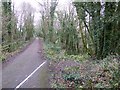
The top of the Rolle Canal inclined plane
Tub boats were hauled from the valley to the higher level of the canal along the inclined plane on the right; they were mainly used to bring limestone to the lime kilns at Taddiport. The white line on the surface of the Tarka Trail (former railway line) marks the extent of the winding house for the boats
Image: © David Smith
Taken: 23 Jan 2015
0.03 miles
2
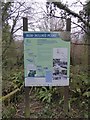
Map and information board for Rolle Canal inclined plane
A sign at the upper level of the inclined plane by the Tarka Trail; the route of the Rolle Canal is waymarked. The railway was built along part of the canal route, and now the Tarka Trail foot and cyclepath follows the dismantled railway
Image: © David Smith
Taken: 23 Jan 2015
0.03 miles
3

Torridge : The Tarka Trail
The Tarka Trail heading through the Torridge District.
Image: © Lewis Clarke
Taken: 3 Mar 2013
0.04 miles
4
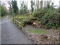
Ruins of Rolle Canal building
The white line on the surface of the Tarka Trail (former railway line) marks the extent of the winding house for the boats, whose vault is on the right of the trail
Image: © David Smith
Taken: 23 Jan 2015
0.04 miles
5
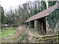
Building for the Rolle Canal inclined plane
The canal boats were hauled up an inclined plane from the lower level of the canal to a higher level. The plane ran through the gate on the left. The restoration project team believe that this was a stable for horses working the canal and inclined plane.
Image: © David Smith
Taken: 23 Jan 2015
0.04 miles
6

Map and description board for Rolle Canal inclined plane
Part of the waymarked path that follows the route of the 19th century canal
Image: © David Smith
Taken: 23 Jan 2015
0.04 miles
7

Surrounded by Woodland
The Tarka Trail runs along the disused railway line in a narrow strip of woodland between the River Torridge and the A386 road.
Image: © Tony Atkin
Taken: 1 Sep 2014
0.07 miles
8
A386 bend ahead
Passing through a pleasant wooded area above the River Torridge with risk of falling rocks from the steep right hand side.
Image: © J.Hannan-Briggs
Taken: 20 Jul 2017
0.08 miles
9
Torridge : The Tarka Trail
The Tarka Trail heading through the countryside on a cold March day.
Image: © Lewis Clarke
Taken: 3 Mar 2013
0.09 miles
10

Torridge : The Tarka Trail
The Tarka Trail heading from Torrington towards Bideford here.
Image: © Lewis Clarke
Taken: 3 Mar 2013
0.13 miles