IMAGES TAKEN NEAR TO
Watkins Way, BIDEFORD, EX39 4FP
Introduction
This page details the photographs taken nearby to Watkins Way, EX39 4FP by members of the Geograph project.
The Geograph project started in 2005 with the aim of publishing, organising and preserving representative images for every square kilometre of Great Britain, Ireland and the Isle of Man.

There are currently over 7.5m images from over14,400 individuals and you can help contribute to the project by visiting https://www.geograph.org.uk
Image Map (Loading...)


Getting Data...Please wait
Leaflet Map data © OpenStreetMap
Images are licensed for reuse under creativecommons.org/licenses/by-sa/2.0
Notes
- Clicking on the map will re-center to the selected point.
- The higher the marker number, the further away the image location is from the centre of the postcode.
Image Listing (15 Images Found)
Images are licensed for reuse under creativecommons.org/licenses/by-sa/2.0
Image
Details
Distance
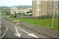
1

Part of a new housing development to the East of Manteo Way, East-The-Water
Image: © Roger A Smith
Taken: 28 Apr 2011
0.01 miles
2
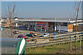
Tesco Supermarket, Maneto Way, East The Water
Image: © Roger A Smith
Taken: 5 Mar 2013
0.08 miles
4
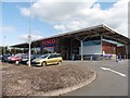
East-The-Water : Tesco
The entrance to Tesco seen from Manteo Way.
Image: © Lewis Clarke
Taken: 5 Feb 2021
0.09 miles
5

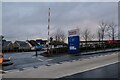
A balancing pond at the top of Watkins Way
"A balancing lake (also "flood basin") is a term used in the U.K. describing an element of an urban drainage system used to control flooding by temporarily storing flood waters. The term balancing pond is also used, though typically for smaller storage facilities for streams and brooks." Wikipedia
Image: © Roger A Smith
Taken: 17 May 2018
0.09 miles
6
Part of a recently completed housing development in East-The-Water
This section of the development is to the east of Manteo way and to the south of the Old Barnstaple Road. It includes Donns Gardens, Watkins Way, Rogers Crescent, Honey Close and a Tesco supermarket.
See also: Image
Image: © Roger A Smith
Taken: 26 Feb 2016
0.09 miles
7
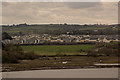
Manteo Way, East-The-Water
One of the main estate roads dropping to the Horwood Stream valley, a tributary of the Torridge. Apologies for some reflections in the bus window.
Image: © Derek Harper
Taken: 27 Sep 2016
0.11 miles
8

A recently completed housing development in East-The-Water
This development sits on both sides of Manteo Way and south of the Old Barnstaple Road.
See also: Image
Image: © Roger A Smith
Taken: 26 Feb 2016
0.11 miles
9

Manteo Way with Bideford New bridge in the background
This scene will change over the next year or so as many new homes are being built on both sides of this new road. The road is named after a town in Canada which in turn was named after a North American Indian.
Image: © Roger A Smith
Taken: 19 Mar 2008
0.12 miles
