IMAGES TAKEN NEAR TO
Huntshaw, TORRINGTON, EX38 7HE
Introduction
This page details the photographs taken nearby to EX38 7HE by members of the Geograph project.
The Geograph project started in 2005 with the aim of publishing, organising and preserving representative images for every square kilometre of Great Britain, Ireland and the Isle of Man.

There are currently over 7.5m images from over14,400 individuals and you can help contribute to the project by visiting https://www.geograph.org.uk
Image Map (Loading...)


Getting Data...Please wait
Leaflet Map data © OpenStreetMap
Images are licensed for reuse under creativecommons.org/licenses/by-sa/2.0
Notes
- Clicking on the map will re-center to the selected point.
- The higher the marker number, the further away the image location is from the centre of the postcode.
Image Listing (30 Images Found)
Images are licensed for reuse under creativecommons.org/licenses/by-sa/2.0
Image
Details
Distance
1
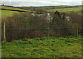
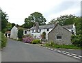
Ford Cottages
Looking right from Image], with the listed cottages https://historicengland.org.uk/listing/the-list/list-entry/1326529 glimpsable through the trees. "Medieval house, of open-hall type, was remodelled in early C17 as a 2-story 3-unit plan with central hall".
Image: © Derek Harper
Taken: 1 Dec 2019
0.01 miles
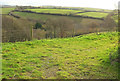
2
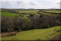
Huntshaw Water
A view over farmland at Huntshaw Water.
Image: © Philip Halling
Taken: 11 Apr 2015
0.03 miles
3
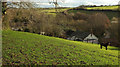
Huntshaw Water
From a gateway close to where Image] was taken. Huntshaw Water Farm, on the right, is listed together with its outbuildings https://historicengland.org.uk/listing/the-list/list-entry/1326530 .
Image: © Derek Harper
Taken: 1 Dec 2019
0.06 miles
4
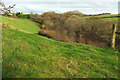
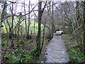
Wood above Huntshaw Water
Image: © Derek Harper
Taken: 1 Dec 2019
0.06 miles
6
Track above Huntshaw Water
Looking right from Image] with a little overlap. Beyond the private grassy track leading to a barn is the Huntshaw Water valley. Glinting on the left is a bend on the lane up to Sheddymoor Farm, whose buildings can be seen a little more to the right, with the Huntshaw Cross transmitter mast behind.
Image: © Derek Harper
Taken: 1 Dec 2019
0.06 miles
7
Lane, Huntshaw Water
Climbing steeply away from the gateway where Image] was taken and thus looking in the opposite direction from Image
Image: © Derek Harper
Taken: 1 Dec 2019
0.07 miles
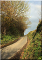
8
Road at Huntshaw Water
County road descending to Huntshaw Water.
Image: © Philip Halling
Taken: 11 Apr 2015
0.08 miles
9
Huntshaw Water
In winter spate east of the bridge near Guscott.
Image: © Jonathan Billinger
Taken: 16 Jan 2008
0.08 miles
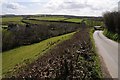
10
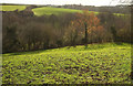
Field, Huntshaw Water
Looking right from Image] down the valley side. By my reckoning, November 30th was still autumn, so those persistent golden leaves are only a day late.
Image: © Derek Harper
Taken: 1 Dec 2019
0.08 miles