IMAGES TAKEN NEAR TO
Kings Nympton, UMBERLEIGH, EX37 9TN
Introduction
This page details the photographs taken nearby to EX37 9TN by members of the Geograph project.
The Geograph project started in 2005 with the aim of publishing, organising and preserving representative images for every square kilometre of Great Britain, Ireland and the Isle of Man.

There are currently over 7.5m images from over14,400 individuals and you can help contribute to the project by visiting https://www.geograph.org.uk
Image Map
Images are licensed for reuse under creativecommons.org/licenses/by-sa/2.0
Notes
- Clicking on the map will re-center to the selected point.
- The higher the marker number, the further away the image location is from the centre of the postcode.
Image Listing (12 Images Found)
Images are licensed for reuse under creativecommons.org/licenses/by-sa/2.0
Image
Details
Distance
1
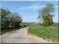
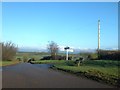
King?s Nympton: by Beara Cross
Looking west towards King’s Nympton village. A beacon stands by the crossroads here
Image: © Martin Bodman
Taken: 23 Jan 2007
0.13 miles
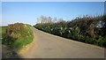
2
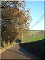
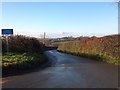
Woodland in the valley south of Beara
The road drops to cross a small stream, then rises past Beara on the northern side of the valley
Image: © David Smith
Taken: 9 Dec 2013
0.14 miles
3
Beara Cross with the beacon on the right
Image: © Sarah Charlesworth
Taken: 24 Jan 2010
0.14 miles
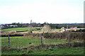
5
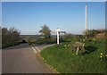
Road to Kings Nympton from Beara Cross
Part of the village is visible. The road drops slightly on its way to the houses on the nearer edge
Image: © David Smith
Taken: 9 Dec 2013
0.14 miles
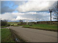
6
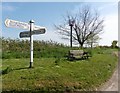
Beara Cross, signpost and seat
The seat looks west towards Kings Nympton, and presumably provides a place to rest for those who have walked up the hill from the village.
Image: © David Smith
Taken: 9 Dec 2013
0.15 miles
7
Beara Cross
Image: © Derek Harper
Taken: 21 Apr 2015
0.15 miles
8
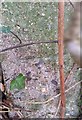
Ordnance Survey Cut Mark
This OS cut mark can be found on a concrete post NW side of crossroads. It marks a point 179.201m above mean sea level.
Image: © Adrian Dust
Taken: 13 Feb 2017
0.15 miles
9
Lane at Beara Cross
Looking along the lane on the right of Image], signposted to Romansleigh. My shadow has crept in. A short way along on the right, on this side of the trees, is a covered reservoir.
Image: © Derek Harper
Taken: 21 Apr 2015
0.16 miles