IMAGES TAKEN NEAR TO
Chittlehampton, UMBERLEIGH, EX37 9QR
Introduction
This page details the photographs taken nearby to EX37 9QR by members of the Geograph project.
The Geograph project started in 2005 with the aim of publishing, organising and preserving representative images for every square kilometre of Great Britain, Ireland and the Isle of Man.

There are currently over 7.5m images from over14,400 individuals and you can help contribute to the project by visiting https://www.geograph.org.uk
Image Map (Loading...)


Getting Data...Please wait
Leaflet Map data © OpenStreetMap
Images are licensed for reuse under creativecommons.org/licenses/by-sa/2.0
Notes
- Clicking on the map will re-center to the selected point.
- The higher the marker number, the further away the image location is from the centre of the postcode.
Image Listing (9 Images Found)
Images are licensed for reuse under creativecommons.org/licenses/by-sa/2.0
Image
Details
Distance
1
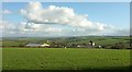
Shilstone
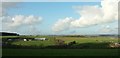
The farm, partly hidden in a dip, seen from the lane past The Wilderness. The old listed farmhouse seems to be out of sight in this view, somewhere to the left of the prominent later farmhouse and the silo tower.
The further farm left of centre is South Newton, with a listed farmhouse, in Image; further off again, right of centre, is Broden Hill. Beyond these are the wooded slopes where the Bray valley meets the Mole valley. We are only just over 150 metres above sea level but it is a fine view.
Image: © Derek Harper
Taken: 8 Feb 2017
0.03 miles
2
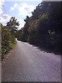
Lane adjacent to Hudscott Wood
A lane bereft of traffic.
Image: © Matthew Hatton
Taken: 27 Sep 2007
0.11 miles
3
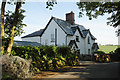
Pretty House on Edge of Woodland
On the other side of the road is "The Wilderness" plantation.
Image: © David Brinicombe
Taken: 14 Jun 2015
0.13 miles
4
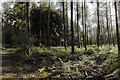
Northern Part of "The Wilderness" Woodland
This planted woodland is associated with Hudscott Manor, once the seat of the Rolle family.
Pine trees predominate on the North side with more hardwood to the South.
Image: © David Brinicombe
Taken: 14 Jun 2015
0.18 miles
5
Farmland around Shilstone
Looking more to the left from where Image] was taken, with part of South Newton on the right, and Shilstone (in Image - see Image]) on the left across a small valley. Behind it are the semis shown in Image]; on the left is The Wilderness.
Image: © Derek Harper
Taken: 8 Feb 2017
0.19 miles
6
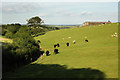
Mixed Grazing and Stream
Cattle and sheep grazing together on a hillside with a tree lined stream meandering by. At the top is Greendown Farm.
Image: © David Brinicombe
Taken: 14 Jun 2015
0.20 miles
7
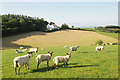
Sheep and Lambs Grazing
Shorn sheep and grown lambs grazing, also with the woodland "The Wilderness" and the house Image in the background. Behind, in the distance, are the roofs of the houses on the B3227 Image which are still in the same grid square.
Image: © David Brinicombe
Taken: 14 Jun 2015
0.22 miles
8
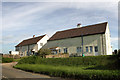
Houses on the B3227 Road
These houses are on the highest section of the B3227 between South Molton and Umberleigh. OS Getamap names these as "four White Gates".
Image: © David Brinicombe
Taken: 14 Jun 2015
0.23 miles
9
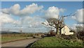
Four White Gates
On the right are the two pairs of semis that give the adjoining crossroads Image] its name. The B3227, here following high ground before dropping to cross the River Bray, is heading for South Molton.
Image: © Derek Harper
Taken: 8 Feb 2017
0.25 miles