IMAGES TAKEN NEAR TO
Warkleigh, UMBERLEIGH, EX37 9DL
Introduction
This page details the photographs taken nearby to EX37 9DL by members of the Geograph project.
The Geograph project started in 2005 with the aim of publishing, organising and preserving representative images for every square kilometre of Great Britain, Ireland and the Isle of Man.

There are currently over 7.5m images from over14,400 individuals and you can help contribute to the project by visiting https://www.geograph.org.uk
Image Map
Images are licensed for reuse under creativecommons.org/licenses/by-sa/2.0
Notes
- Clicking on the map will re-center to the selected point.
- The higher the marker number, the further away the image location is from the centre of the postcode.
Image Listing (16 Images Found)
Images are licensed for reuse under creativecommons.org/licenses/by-sa/2.0
Image
Details
Distance
1
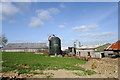
Farmyard with Grain Silo (black) and Grain Dryer (silver)
Image: © David Brinicombe
Taken: 16 May 2015
0.02 miles
2
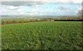
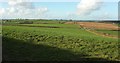
Field near Hilltown
Looking right from where Image] was taken. In the distance is South Molton. The prominent wood right of centre is Vitland Wood on the east slopes of the Bray valley - see Image
Image: © Derek Harper
Taken: 8 Feb 2017
0.11 miles
3
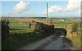
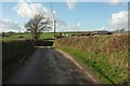
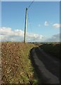
Lane to Hilltown Cross
Descending from the farm at Hilltown to the crossroads, which is at a little col. Right of centre is Greendown Farm.
Image: © Derek Harper
Taken: 8 Feb 2017
0.12 miles
4
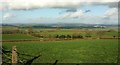
Countryside northeast of Warkleigh
Looking right from where Image] was taken. The farm left of centre is South Newton. In the distance on the right is the Norbord chipboard factory.
Image: © Derek Harper
Taken: 8 Feb 2017
0.15 miles
5
Lane to Hilltown
From the same point as Image], looking in the opposite direction. Hilltown is the farm in the background, in Image
Image: © Derek Harper
Taken: 8 Feb 2017
0.16 miles
6
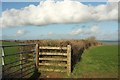
Field boundary near Hilltown
A hedge and fence leading away from the lane between Hilltown and Satterleigh.
Image: © Derek Harper
Taken: 8 Feb 2017
0.18 miles
7
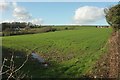
Field, Warkleigh
On the left is Higher Beers Farm with a listed farmhouse https://www.historicengland.org.uk/listing/the-list/list-entry/1258618 . On the extreme right is a bungalow at Hilltown, in Image
Image: © Derek Harper
Taken: 8 Feb 2017
0.18 miles
8
Lane from Hilltown Cross
Leading away from the signpost shown in Image up towards the farm at Hilltown.
Image: © Derek Harper
Taken: 8 Feb 2017
0.20 miles
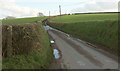
9
Lane to Satterleigh
Image: © Derek Harper
Taken: 8 Feb 2017
0.20 miles
10
Farmland around Hilltown Cross
A clearer view of the crossroads mentioned at Image], rather obscured there by the gate from which this was taken. On the extreme left is the farm (listed farmhouse https://www.historicengland.org.uk/listing/the-list/list-entry/1258726 ) at Pugsley, in Image
Image: © Derek Harper
Taken: 8 Feb 2017
0.22 miles