IMAGES TAKEN NEAR TO
The Lees, ILFRACOMBE, EX34 8RE
Introduction
This page details the photographs taken nearby to The Lees, EX34 8RE by members of the Geograph project.
The Geograph project started in 2005 with the aim of publishing, organising and preserving representative images for every square kilometre of Great Britain, Ireland and the Isle of Man.

There are currently over 7.5m images from over14,400 individuals and you can help contribute to the project by visiting https://www.geograph.org.uk
Image Map (Loading...)


Getting Data...Please wait
Leaflet Map data © OpenStreetMap
Images are licensed for reuse under creativecommons.org/licenses/by-sa/2.0
Notes
- Clicking on the map will re-center to the selected point.
- The higher the marker number, the further away the image location is from the centre of the postcode.
Image Listing (26 Images Found)
Images are licensed for reuse under creativecommons.org/licenses/by-sa/2.0
Image
Details
Distance

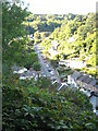
2

Houses on a section of Slade Valley Road viewed across the West Wilder Brook.
Image: © Roger A Smith
Taken: 7 Sep 2008
0.05 miles
3

Ilfracombe : The Tarka Trail
The Tarka Trail heading out from Ilfracombe and into the North Devon countryside.
Image: © Lewis Clarke
Taken: 23 Aug 2014
0.06 miles
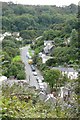
4
Lower Slade
Seen from the cycle track on the old railway line.
Image: © Rod Allday
Taken: 26 Sep 2010
0.07 miles
5

National Cycle Network route 27
Route 27 is part of the Devon Coast to Coast route which runs from Ilfracombe to Plymouth. This section follows the course of the old Ilfracombe railway branch. The rather puzzling sign on the right refers to cycling within the adjacent nature reserve, which is accessed via the path on the right.
Image: © Rod Allday
Taken: 26 Sep 2010
0.07 miles
6
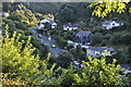
Ilfracombe : Lower Slade
Looking down from the Tarka Trail towards Lower Slade.
Image: © Lewis Clarke
Taken: 23 Aug 2014
0.08 miles
7

The junction of Slade Road with Slade Valley Road.
Image: © Roger A Smith
Taken: 7 Sep 2008
0.08 miles
8

Ilfracombe : The Tarka Trail
The Tarka Trail heads out of Ilfracombe.
Image: © Lewis Clarke
Taken: 23 Aug 2014
0.10 miles
9
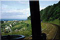
By rail to Ilfracombe, 1969
The final descent into Ilfracombe , viewed through the driver's cab of a DMU, August 1969. A somewhat alarming prospect, as the station (the whitish buildings) appears to be a ski jump into the sea - what if the brakes failed? Actually the station was some way inland above the town centre.
Image: © Robin Webster
Taken: Unknown
0.12 miles
10
Slade Road with Saltmer Close just visible on the left.
Image: © Roger A Smith
Taken: 7 Sep 2008
0.12 miles