IMAGES TAKEN NEAR TO
Meadow Close, BARNSTAPLE, EX32 0NB
Introduction
This page details the photographs taken nearby to Meadow Close, EX32 0NB by members of the Geograph project.
The Geograph project started in 2005 with the aim of publishing, organising and preserving representative images for every square kilometre of Great Britain, Ireland and the Isle of Man.

There are currently over 7.5m images from over14,400 individuals and you can help contribute to the project by visiting https://www.geograph.org.uk
Image Map
Images are licensed for reuse under creativecommons.org/licenses/by-sa/2.0
Notes
- Clicking on the map will re-center to the selected point.
- The higher the marker number, the further away the image location is from the centre of the postcode.
Image Listing (28 Images Found)
Images are licensed for reuse under creativecommons.org/licenses/by-sa/2.0
Image
Details
Distance
2
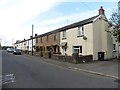
Landkey : Newland
A road heading through the village.
Image: © Lewis Clarke
Taken: 22 Dec 2016
0.06 miles
3

Swimbridge : Landkey Scenery
Looking across the countryside towards Landkey.
Image: © Lewis Clarke
Taken: 2 Mar 2020
0.07 miles
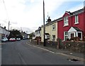
4
Approaching Landkey
Landkey is a fairly large village just outside Barnstaple, although confusingly this end of it is called Swimbridge Newland. Until the A361 North Devon Link was built, this was the main route into North Devon, a long tedious drive from Taunton through a series of small villages and towns.
Image: © Stephen McKay
Taken: 8 Nov 2007
0.08 miles
5

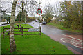
Welcome to Landkey
A sign and physical reminder of the edge of the village
Image: © David Smith
Taken: 9 Jun 2014
0.11 miles
7
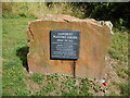
Landkey Playing Fields
Commemorative plaque of opening of Landkey Playing Fields in 1958.
Image: © Charles Fowler
Taken: 3 Aug 2013
0.17 miles
8
A waterway joining another waterway which runs into Venn Stream
This waterway has its source near Broomscott Farm and is one of a number of streams which eventually feed into Venn Stream.
Image: © Roger A Smith
Taken: 18 Nov 2012
0.18 miles
9
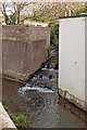
A waterway alongside Tanners Lane
This waterway, which joins Venn Stream, runs parallel to Tanners Lane before passing underneath and away north east towards its source at Gunn.
Image: © Roger A Smith
Taken: 18 Nov 2012
0.18 miles
10

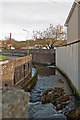
A stream running alongside Tanners Lane then under Blakes Hill Road
Shortly after passing under Blakes Hill Road this stream joins Venn Stream.
Image: © Roger A Smith
Taken: 18 Nov 2012
0.19 miles