IMAGES TAKEN NEAR TO
Parracombe, BARNSTAPLE, EX31 4RF
Introduction
This page details the photographs taken nearby to EX31 4RF by members of the Geograph project.
The Geograph project started in 2005 with the aim of publishing, organising and preserving representative images for every square kilometre of Great Britain, Ireland and the Isle of Man.

There are currently over 7.5m images from over14,400 individuals and you can help contribute to the project by visiting https://www.geograph.org.uk
Image Map
Images are licensed for reuse under creativecommons.org/licenses/by-sa/2.0
Notes
- Clicking on the map will re-center to the selected point.
- The higher the marker number, the further away the image location is from the centre of the postcode.
Image Listing (9 Images Found)
Images are licensed for reuse under creativecommons.org/licenses/by-sa/2.0
Image
Details
Distance

2

Field below Woolhanger Farm
The drainage in the valley feeds Barbrook and West Lyn River.
Image: © Bill Boaden
Taken: 28 Dec 2016
0.10 miles
3

Track up to Woolhanger Farm
Part of a bridleway connecting Thornworthy with Martinhoe.
Image: © Bill Boaden
Taken: 28 Dec 2016
0.11 miles
4

Fields above Woolhanger Farm
The sheds house beef cattle as their winter quarters.
Image: © Bill Boaden
Taken: 28 Dec 2016
0.11 miles
5

Woolhanger Farmhouse
The centre of a working cattle farm. The site is also a venue for weddings with the Music Room visible in the middle being the focus for these.
Image: © Bill Boaden
Taken: 28 Dec 2016
0.11 miles
6
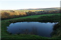
Pond near Woolhanger Farm
With a view to higher Exmoor hills.
Image: © Bill Boaden
Taken: 28 Dec 2016
0.13 miles
7

Combe below Barham Hill
One of many combes draining off Exmoor towards Lynmouth.
Image: © Bill Boaden
Taken: 28 Dec 2016
0.16 miles
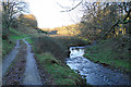
8

Bridleway to Thornworthy
Crossing a valley bottom below Woolhanger Farm.
Image: © Bill Boaden
Taken: 28 Dec 2016
0.18 miles
9
Bridleway towards West Ilkerton
This is the former access to Woolhanger Farm. It gets quite muddy further on.
Image: © Bill Boaden
Taken: 28 Dec 2016
0.20 miles