IMAGES TAKEN NEAR TO
Riverside Road, BARNSTAPLE, EX31 1LY
Introduction
This page details the photographs taken nearby to Riverside Road, EX31 1LY by members of the Geograph project.
The Geograph project started in 2005 with the aim of publishing, organising and preserving representative images for every square kilometre of Great Britain, Ireland and the Isle of Man.

There are currently over 7.5m images from over14,400 individuals and you can help contribute to the project by visiting https://www.geograph.org.uk
Image Map
Images are licensed for reuse under creativecommons.org/licenses/by-sa/2.0
Notes
- Clicking on the map will re-center to the selected point.
- The higher the marker number, the further away the image location is from the centre of the postcode.
Image Listing (39 Images Found)
Images are licensed for reuse under creativecommons.org/licenses/by-sa/2.0
Image
Details
Distance
1
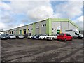
Industrial units, Pottington Business Park
Image: © Roger Cornfoot
Taken: 11 Mar 2019
0.04 miles
2
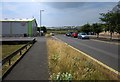
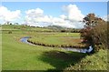
Riverside Road, Pottington Business Park
Well, I suppose the units on the left, southwest, side of the road, might get close to the riverside, the river being the Taw. Here the end of the road is almost reached with Riverside Units on the left. Beyond, marshy meadows (Bradiford Reserve) around Bradiford Water take over.
Image: © Derek Harper
Taken: 18 Jul 2013
0.06 miles
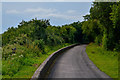
3
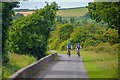
Barnstaple : Tarka Trail
Looking along the Tarka Trail heading out from Barnstaple.
Image: © Lewis Clarke
Taken: 20 Jun 2020
0.07 miles
4
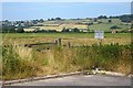
Bradiford Reserve
The end of the business park road shown in Image], with a nature reserve occupying the marshy meadows around Bradiford Water. See http://www.devonbirds.org/birdwatching/places_to_go/bradiford . The village to the left is Ashford, in Image
Image: © Derek Harper
Taken: 18 Jul 2013
0.08 miles
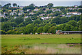
5
Bradiford Water Bird Reserve, Barnstaple
Water meadows, scrapes and ponds just before confluence of Bradiford Water and River Taw. Situated at west end of Pottington Industrial Estate, Barnstaple. Image taken from the Tarka Trail (old trackbed of the Barnstaple to Ilfracombe Railway) looking east with Roborough (iron age fort) in far background.
Image: © Maurice Clements
Taken: 24 Oct 2006
0.10 miles
6
Barnstaple : Grassy Field & Cattle
Cows in a grassy field.
Image: © Lewis Clarke
Taken: 20 Jun 2020
0.11 miles
7
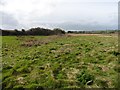
Rough ground near the outfall of Bradiford Water
Image: © Roger Cornfoot
Taken: 11 Mar 2019
0.11 miles
8
Barnstaple : Tarka Trail
Looking along the Tarka Trail.
Image: © Lewis Clarke
Taken: 20 Jun 2020
0.11 miles
9
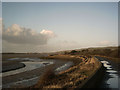
Taw Estuary and South West Coastpath
The Tarka Trail / South West Coastpath near where Bradiford Water joins the River Taw.
Image: © Grant Sherman
Taken: 11 Jan 2006
0.12 miles
10
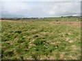
Rough ground near the outfall of Bradiford Water
Image: © Roger Cornfoot
Taken: 11 Mar 2019
0.13 miles