IMAGES TAKEN NEAR TO
Apple Farm Grange, EXETER, EX2 7TH
Introduction
This page details the photographs taken nearby to Apple Farm Grange, EX2 7TH by members of the Geograph project.
The Geograph project started in 2005 with the aim of publishing, organising and preserving representative images for every square kilometre of Great Britain, Ireland and the Isle of Man.

There are currently over 7.5m images from over14,400 individuals and you can help contribute to the project by visiting https://www.geograph.org.uk
Image Map
Images are licensed for reuse under creativecommons.org/licenses/by-sa/2.0
Notes
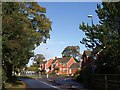
- Clicking on the map will re-center to the selected point.
- The higher the marker number, the further away the image location is from the centre of the postcode.
Image Listing (80 Images Found)
Images are licensed for reuse under creativecommons.org/licenses/by-sa/2.0
Image
Details
Distance
2
Russell Way, Exeter
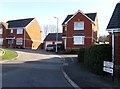
Taken from the north end of the bridge across the A3015 from which Image was taken. At the roundabout, Russell Way turns left, Clyst Halt Avenue continues straight ahead, and the new housing is on a cul-de-sac, Apple Farm Grange. The second road name commemorates a former railway station, Clyst St Mary and Digby Halt, which existed from 1908 to 1948 on the nearby Exmouth railway line.
Image: © Derek Harper
Taken: 4 Nov 2009
0.03 miles
3

The A379, and the junction for Sandy Park rugby grounds
The blue building in the distance is the new Exeter Ikea store being built
Image: © Rob Purvis
Taken: 31 Jan 2018
0.10 miles
4
A3015 from Russell Way
Taken from a bridge carrying the slip road seen on the left, which curves right round as described in Image
Image: © Derek Harper
Taken: 4 Nov 2009
0.10 miles

6

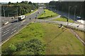
Junction on A379
A view from the Baker Bridge of the junction with the entrance to the Exeter Chiefs' rugby ground. The OS maps current as I submit fail to show the links across to the nearer carriageway, indicating that you needed to be on the southwest-bound carriageway to access the ground.
Image: © Derek Harper
Taken: 3 Jun 2017
0.11 miles
7
Junction on A379
Another view of the junction shown in Image], from further south along Baker Bridge, with the entrance to the Exeter Chiefs' rugby ground on the left. The next bridge along carries the railway line between Newcourt and Digby & Sowton.
Image: © Derek Harper
Taken: 3 Jun 2017
0.11 miles
8

New houses being built, seen from the footpath from Sandy Park rugby grounds
Image: © Rob Purvis
Taken: 1 Feb 2018
0.11 miles
9
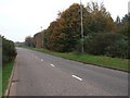
Road beside a housing estate
This road skirts around a housing estate. Beyond the mature trees is a link to the M5 from the former Exeter bypass
Image: © David Smith
Taken: 30 Oct 2009
0.11 miles
10
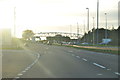
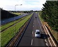
Exeter : The A379
The A379 heading into Exeter from East Devon and the M5 Motorway.
Image: © Lewis Clarke
Taken: 4 Nov 2013
0.11 miles