IMAGES TAKEN NEAR TO
Bardon Walk, EXETER, EX2 7PP
Introduction
This page details the photographs taken nearby to Bardon Walk, EX2 7PP by members of the Geograph project.
The Geograph project started in 2005 with the aim of publishing, organising and preserving representative images for every square kilometre of Great Britain, Ireland and the Isle of Man.

There are currently over 7.5m images from over14,400 individuals and you can help contribute to the project by visiting https://www.geograph.org.uk
Image Map
Images are licensed for reuse under creativecommons.org/licenses/by-sa/2.0
Notes
- Clicking on the map will re-center to the selected point.
- The higher the marker number, the further away the image location is from the centre of the postcode.
Image Listing (103 Images Found)
Images are licensed for reuse under creativecommons.org/licenses/by-sa/2.0
Image
Details
Distance
1
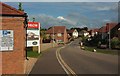
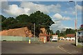
Bishop's Way, Exeter
Another view along Image] with the electricity sub station shown in Image] on the immediate left. The notice it carries refers to "match days", reflecting the fact that it is a fairly short walk along footpaths to the ground of the Exeter Chiefs, currently Rugby Premiership champions. I wonder how many new occupants are rugby fans?
Image: © Derek Harper
Taken: 3 Jun 2017
0.02 miles
2
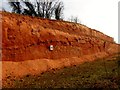
A Slice Through Exeter's Earth
This exposed slice of Exeter's earth seen close to the M5 motorway and was cut 3 years ago to allow the building of out of town stores like Toys R Us and Snow and Rock. I passed here most days on the way to Clyst House and was attracted by its deep colour.
Image: © Rude Health
Taken: 22 Mar 2012
0.02 miles
3
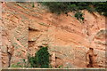
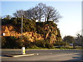
Sandstone cliff near Bishop's Way
Taken from the footpath shown in Image http://www.devon.gov.uk/overview_report_whole.pdf , page 29 ff, gives a good description of the geology of this former new red sandstone quarry, part of which is reproduced at Image
Image: © Derek Harper
Taken: 3 Jun 2017
0.03 miles
4
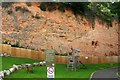
Former quarry, Bishop's Way, Exeter
The new red sandstone cliff now forms a backdrop to a play area. The path links the new housing shown in Image] to the Sidmouth Road close to a handy bus stop and the Park and Ride. See also Image
Image: © Derek Harper
Taken: 3 Jun 2017
0.04 miles
5
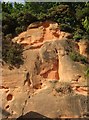
Sandstone cliff by Bishop's Way
"The Dawlish Sandstone Formation of Permian age, about 260 million years old, worked at Bishops Court Quarry displays large scale cross bedding ... These are classic desert dune sands comprising red and yellowish brown, well to moderately-well sorted, medium grain-size sand with occasional layers of fine silty sand and red-brown mudstone ... Many of the sand grains are well rounded and often spherical (‘millet seed’ sand grains) believed to be a characteristic of coarser varieties of wind blown material" http://www.devon.gov.uk/overview_report_whole.pdf . This cliff is on the left of the camera in Image
Image: © Derek Harper
Taken: 3 Jun 2017
0.04 miles
6
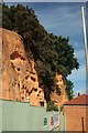
Sandstone cliff by Bishop's Way
An alternative view of Image], with an electricity sub station beneath it, and a fence to deter access to what must be an unstable cliff.
Image: © Derek Harper
Taken: 3 Jun 2017
0.04 miles
7
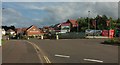
Bishop's Way, Exeter
New housing built within a disused sandstone quarry, of which some cliff faces remain. The roundabout is at the junction with Apple Lane, which has the distinction of leaving the junction twice as an industrial estate road and once as a footpath.
Image: © Derek Harper
Taken: 3 Jun 2017
0.04 miles
8
Path to Bishop's Way
From its junction with the Sidmouth Road. The sandstone cliff shown in Image can be seen ahead.
Image: © Derek Harper
Taken: 5 Oct 2019
0.04 miles
9
A little bit of Devon's geology
A sandstone outcrop at Bishops Court quarry.
Image: © Anthony Vosper
Taken: 13 Jan 2013
0.04 miles
10
Junction on Apple Lane
Another view of the roundabout shown in Image], with the quarry cliff face shown in Image] and Image] in the background, by the electricity sub station.
Image: © Derek Harper
Taken: 3 Jun 2017
0.05 miles