IMAGES TAKEN NEAR TO
Sandstone Close, EXETER, EX2 7PG
Introduction
This page details the photographs taken nearby to Sandstone Close, EX2 7PG by members of the Geograph project.
The Geograph project started in 2005 with the aim of publishing, organising and preserving representative images for every square kilometre of Great Britain, Ireland and the Isle of Man.

There are currently over 7.5m images from over14,400 individuals and you can help contribute to the project by visiting https://www.geograph.org.uk
Image Map (Loading...)


Getting Data...Please wait
Leaflet Map data © OpenStreetMap
Images are licensed for reuse under creativecommons.org/licenses/by-sa/2.0
Notes
- Clicking on the map will re-center to the selected point.
- The higher the marker number, the further away the image location is from the centre of the postcode.
Image Listing (93 Images Found)
Images are licensed for reuse under creativecommons.org/licenses/by-sa/2.0
Image
Details
Distance
1

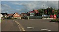
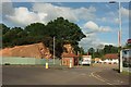
Trade City warehouses
Warehouses and offices in Apple Lane, a recent extension of Sowton Industrial Estate.
Image: © David Smith
Taken: 30 Oct 2009
0.02 miles
2

Sandstone Close, Exeter
Part of a recent housing estate built within the former Bishop's Court sand quarry, hence the name of the cul-de-sac. Seen from Apple lane, a path and cycle track here running along the top of the one of the former quarry cliffs. The distant white building on the left must be the new DPD depot at Skypark near the airport.
Image: © Derek Harper
Taken: 3 Jun 2017
0.02 miles
3

Apple Lane
The footpath shares the name of the roads in the nearby industrial estate, but this roughly follows the line of the former lane from the old A35 to Digby Hospital.
Image: © Derek Harper
Taken: 3 Jun 2017
0.04 miles
4
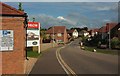
Bishop's Way, Exeter
New housing built within a disused sandstone quarry, of which some cliff faces remain. The roundabout is at the junction with Apple Lane, which has the distinction of leaving the junction twice as an industrial estate road and once as a footpath.
Image: © Derek Harper
Taken: 3 Jun 2017
0.04 miles
5
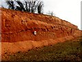
A Slice Through Exeter's Earth
This exposed slice of Exeter's earth seen close to the M5 motorway and was cut 3 years ago to allow the building of out of town stores like Toys R Us and Snow and Rock. I passed here most days on the way to Clyst House and was attracted by its deep colour.
Image: © Rude Health
Taken: 22 Mar 2012
0.04 miles
6
Bishop's Way, Exeter
Another view along Image] with the electricity sub station shown in Image] on the immediate left. The notice it carries refers to "match days", reflecting the fact that it is a fairly short walk along footpaths to the ground of the Exeter Chiefs, currently Rugby Premiership champions. I wonder how many new occupants are rugby fans?
Image: © Derek Harper
Taken: 3 Jun 2017
0.05 miles
7
Apple Lane
Actually most of the roads and cul-de-sacs around here, not to mention footpaths, seem to be called Apple Lane. This branch leads to "Trade City upper level".
Image: © Derek Harper
Taken: 3 Jun 2017
0.06 miles
8
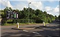
Junction on Apple Lane
Another view of the roundabout shown in Image], with the quarry cliff face shown in Image] and Image] in the background, by the electricity sub station.
Image: © Derek Harper
Taken: 3 Jun 2017
0.06 miles
9

Sandy Way, Exeter
From Apple Lane, the path on the left leading to Apple Lane, the industrial estate, with a branch path into the new housing off Bishop's Way. The houses are also shown in Image] and Image
Image: © Derek Harper
Taken: 3 Jun 2017
0.06 miles
10
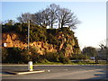
A little bit of Devon's geology
A sandstone outcrop at Bishops Court quarry.
Image: © Anthony Vosper
Taken: 13 Jan 2013
0.06 miles