IMAGES TAKEN NEAR TO
Glasshouse Lane, EXETER, EX2 7DA
Introduction
This page details the photographs taken nearby to Glasshouse Lane, EX2 7DA by members of the Geograph project.
The Geograph project started in 2005 with the aim of publishing, organising and preserving representative images for every square kilometre of Great Britain, Ireland and the Isle of Man.

There are currently over 7.5m images from over14,400 individuals and you can help contribute to the project by visiting https://www.geograph.org.uk
Image Map (Loading...)


Getting Data...Please wait
Leaflet Map data © OpenStreetMap
Images are licensed for reuse under creativecommons.org/licenses/by-sa/2.0
Notes
- Clicking on the map will re-center to the selected point.
- The higher the marker number, the further away the image location is from the centre of the postcode.
Image Listing (116 Images Found)
Images are licensed for reuse under creativecommons.org/licenses/by-sa/2.0
Image
Details
Distance
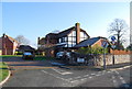
1

Waymark beside Bridge Road, Countess Wear, Exeter
There is no explanation about what this item is marking! The design on top seems to represent a winding river, and the plaque on the post does not help.
Image: © David Smith
Taken: 9 Apr 2009
0.02 miles
3
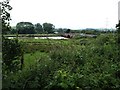
Looking towards Countess Wear Bridge from Glasshouse Lane
The River Exe is right up to the top of its banks after heavy June rainfall. In another year, it might have been described as unusually heavy rainfall for June, but in 2012 it seems to have become the norm.
Image: © David Gearing
Taken: 24 Jun 2012
0.03 miles
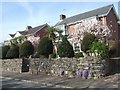
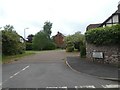
4
Glasshouse Lane, Countess Wear, Exeter
An old road, as the glasshouse existed in the 17th and 18th centuries, now leading to a 20th century housing estate
Image: © David Smith
Taken: 6 Apr 2020
0.06 miles
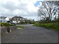
5
Roche Garden, Countess Wear
A modern housing development in Countess Wear
Image: © N Chadwick
Taken: 28 Dec 2008
0.06 miles
6

Preparing for construction work, Bridge Road, Countess Wear
Preparing to widen Countess Wear Bridge over the River Exe; the stone wall is the parapet of the current bridge and the fence is the boundary of the neighbouring property
Image: © David Smith
Taken: 18 Aug 2016
0.07 miles
8
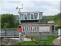
Control room for the swing bridges at Countess Wear
Image: © Sarah Charlesworth
Taken: 3 May 2009
0.09 miles
9

Sundial on Countess Wear House
The dial is dated 1715
Image: © David Smith
Taken: 20 Aug 2009
0.09 miles
10
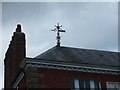
Windvane on Countess Wear House
Like the sundial (Image]) this is dated 1715. Cherry and Pevsner have little to say about the building: "appears to be a substantial late C18 house revamped c.1900" and in the process give it the wrong house number. It is grade II listed, and the listing mentions that it was built circa 1770 and revammped in the Queen Anne Style in 1889. Why the date of 1715?
Image: © David Smith
Taken: 20 Aug 2009
0.09 miles