IMAGES TAKEN NEAR TO
Magdalen Road, EXETER, EX2 4TE
Introduction
This page details the photographs taken nearby to Magdalen Road, EX2 4TE by members of the Geograph project.
The Geograph project started in 2005 with the aim of publishing, organising and preserving representative images for every square kilometre of Great Britain, Ireland and the Isle of Man.

There are currently over 7.5m images from over14,400 individuals and you can help contribute to the project by visiting https://www.geograph.org.uk
Image Map
Images are licensed for reuse under creativecommons.org/licenses/by-sa/2.0
Notes
- Clicking on the map will re-center to the selected point.
- The higher the marker number, the further away the image location is from the centre of the postcode.
Image Listing (376 Images Found)
Images are licensed for reuse under creativecommons.org/licenses/by-sa/2.0
Image
Details
Distance
1
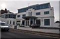
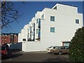
Exeter : Zenith House
Zenith House which is home to the Exeter Hip and Knee Clinic on Magdalen Road.
Image: © Lewis Clarke
Taken: 21 Sep 2012
0.01 miles
2
41 Magdalen Road, Exeter
A pleasing Art Deco interlude to the local Victoriana.
Built as a garage, Zenith House has been converted into flats, and an office range fronting the main road (occupied by Gap Personnel at the time).
Image: © Stephen Richards
Taken: 18 Jun 2014
0.01 miles
3

Zenith House, Exeter
According to Cherry & Pevsner, this was an "art deco filling station (surprisingly unaltered)". It has now been transformed into prestige offices.
Image: © Derek Harper
Taken: 1 Dec 2008
0.01 miles
4
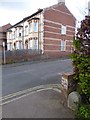
Boundary marker and houses, Magdalen Road, Exeter
This stone marked where the boundary of the city and municipality reached Magdalen Road from the north, and then followed the road to the west (as marked on the 1880-1890 OS map). On the wall alongside is a benchmark (described on the Bench Mark Database at http://www.bench-marks.org.uk/bm40171) Image
Image: © David Smith
Taken: 4 Mar 2016
0.02 miles
5
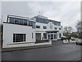
Zenith House, Magdalen Road, Exeter
This 1930's Art Deco building formerly housed a garage and car dealership. It has been converted into offices with flats above
Image: © David Smith
Taken: 31 Dec 2016
0.02 miles
6
Zenith house flats
A block of luxury flats in a converted car showrooms, dating from the 1930's
Image: © David Smith
Taken: 7 Mar 2010
0.02 miles
7
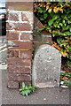
Benchmark at end of wall on College Avenue
Ordnance Survey cut mark benchmark described on the Bench Mark Database at http://www.bench-marks.org.uk/bm40171
Image: © Roger Templeman
Taken: 23 Nov 2011
0.03 miles
8

Junction of Magdalen Road and College Avenue
On the end of the wall, beside a boundary stone, is an OS benchmark Image
Image: © Roger Templeman
Taken: 23 Nov 2011
0.03 miles
9

Service road for houses in St Leonards Road, Exeter
Image: © David Smith
Taken: 26 Mar 2020
0.03 miles
10

Old Parish Boundary Marker by Magdalen Road, Exeter Parish
Parish Boundary Marker by the UC road, in parish of Exeter (Exeter District), Magdalen Road, at junction with College Avenue, at back of pavement, beside end of brick wall, North side of road.
Inscription reads:- : 18 / H | P / (97 ) :
Surveyed
Milestone Society National ID: DV_EXHT01apb
Image: © Alan Rosevear
Taken: 17 Apr 2011
0.03 miles