IMAGES TAKEN NEAR TO
Weirfield Path, EXETER, EX2 4DR
Introduction
This page details the photographs taken nearby to Weirfield Path, EX2 4DR by members of the Geograph project.
The Geograph project started in 2005 with the aim of publishing, organising and preserving representative images for every square kilometre of Great Britain, Ireland and the Isle of Man.

There are currently over 7.5m images from over14,400 individuals and you can help contribute to the project by visiting https://www.geograph.org.uk
Image Map
Images are licensed for reuse under creativecommons.org/licenses/by-sa/2.0
Notes
- Clicking on the map will re-center to the selected point.
- The higher the marker number, the further away the image location is from the centre of the postcode.
Image Listing (603 Images Found)
Images are licensed for reuse under creativecommons.org/licenses/by-sa/2.0
Image
Details
Distance
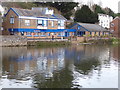
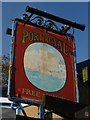
1
The Port Royal public house seen across the Exeter Ship Canal
The canal is in the foreground. The River Exe is hidden between the canal and the public house.
Image: © Chris Allen
Taken: 28 May 2021
0.00 miles
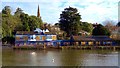
2
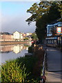
The Port Royal, Exeter
A pub beside the River Exe, with a landing stage. The pale building upstream is part of the Haven Banks flats development overlooking Piazza Terracina.
Image: © Derek Harper
Taken: 25 Sep 2006
0.01 miles
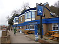
3
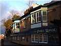
The Port Royal
The riverside Weirfield Path is the best means of reaching this, the longest pub in Exeter (courtesy of an adjoining former boat house, now a restaurant).
Image: © Derek Harper
Taken: 22 Jan 2007
0.01 miles
4
The Port Royal, Exeter
Public house seen across the River Exe from Haven Banks.
Image: © Chris Allen
Taken: 24 Dec 2017
0.02 miles
5
Orange Way in Devon and Torbay (251)
The "Port Royal" PH is on the east bank of the river.
Image: © Shazz
Taken: 17 Nov 2011
0.02 miles
7
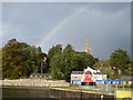
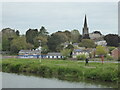
Rainbow over the River Exe
A double bow (outer one is faint) over the trees of Larkbeare House, the spire of St Leonard's church and the Port Royal Inn
Image: © David Smith
Taken: 17 Oct 2016
0.02 miles
8
The Port Royal
Public house by the River Exe, Exeter.
Image: © Chris Allen
Taken: 30 Mar 2015
0.02 miles
9

Port Royal Inn, River Exe in reduced flow
In February 2008, the Environment Agency carried out survey and dredging work on the River Exe between Millers Bridge (SX914926) and Trews Weir (SX924915) which meant that the river level was lowered by between 1 and 2 metres. This is one of a set of pictures showing the river in such unusual circumstances. The pictures of the quay form a panorama showing some of the bedrock on which the quay was built.
Image: © David Smith
Taken: 15 Feb 2008
0.02 miles
10

Houses at the foot of Weirfield Road, Exeter
Image: © David Smith
Taken: 20 Dec 2019
0.02 miles