IMAGES TAKEN NEAR TO
COLYTON, EX24 6SP
Introduction
This page details the photographs taken nearby to EX24 6SP by members of the Geograph project.
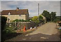
The Geograph project started in 2005 with the aim of publishing, organising and preserving representative images for every square kilometre of Great Britain, Ireland and the Isle of Man.

There are currently over 7.5m images from over14,400 individuals and you can help contribute to the project by visiting https://www.geograph.org.uk
Image Map
Images are licensed for reuse under creativecommons.org/licenses/by-sa/2.0
Notes
- Clicking on the map will re-center to the selected point.
- The higher the marker number, the further away the image location is from the centre of the postcode.
Image Listing (30 Images Found)
Images are licensed for reuse under creativecommons.org/licenses/by-sa/2.0
Image
Details
Distance
1
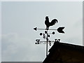
Channel to Channel (62)
This weathercock is on Watery Lane.
Image: © Shazz
Taken: 14 Sep 2014
0.01 miles
2
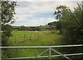
Field by Watery Lane
The other side of the hedge from Image], so this is again the flood plain of the Umborne Brook valley, and Langdown Plantation is on the hill to the right.
Image: © Derek Harper
Taken: 28 Aug 2012
0.05 miles
3
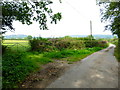
Channel to Channel (61)
Watery Lane passes a field entrance.
Image: © Shazz
Taken: 14 Sep 2014
0.06 miles
4
Channel to Channel (63)
These buildings are at Tritchmarsh.
See http://www.geograph.org.uk/photo/3111705 for an earlier view.
Image: © Shazz
Taken: 14 Sep 2014
0.06 miles
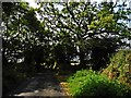
5
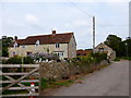
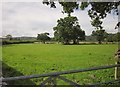
Tritchmarsh
The public road section of Watery Lane ends as the lane passes this farm in the Umborne Brook valley, but the lane continues as a green lane with public access towards Lexhayne Mill, giving access to footpaths.
Image: © Derek Harper
Taken: 28 Aug 2012
0.07 miles
6
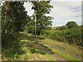
Field at Tritchmarsh
From Watery Lane just north of the farm, as it becomes a green lane.
Image: © Derek Harper
Taken: 28 Aug 2012
0.07 miles
7
Watery Lane
The green lane is about to live up to its name as it crosses the flood plain of the Umborne Brook valley. However, the little timber bridge between the telegraph poles is crossed by Shute Footpath 7, which helps avoid the worst of the flood. This was taken from the same spot as Image
Image: © Derek Harper
Taken: 28 Aug 2012
0.10 miles
8
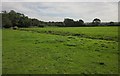
Meadow at Tritchmarsh
A drainage channel runs across this meadow on the flood plain of the Umborne Brook valley. This is from the same spot as Image
Image: © Derek Harper
Taken: 28 Aug 2012
0.10 miles
10
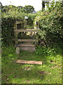
Stile to Watery Lane
See Image; the crosspiece has fallen away, making this stile on Shute Footpath 7 a little awkward.
Image: © Derek Harper
Taken: 28 Aug 2012
0.11 miles