IMAGES TAKEN NEAR TO
Parc Fer Close, BUDE, EX23 9TA
Introduction
This page details the photographs taken nearby to Parc Fer Close, EX23 9TA by members of the Geograph project.
The Geograph project started in 2005 with the aim of publishing, organising and preserving representative images for every square kilometre of Great Britain, Ireland and the Isle of Man.

There are currently over 7.5m images from over14,400 individuals and you can help contribute to the project by visiting https://www.geograph.org.uk
Image Map
Images are licensed for reuse under creativecommons.org/licenses/by-sa/2.0
Notes
- Clicking on the map will re-center to the selected point.
- The higher the marker number, the further away the image location is from the centre of the postcode.
Image Listing (49 Images Found)
Images are licensed for reuse under creativecommons.org/licenses/by-sa/2.0
Image
Details
Distance
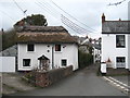
1

Bridge Cottages Stratton
Grade II listed, probably with C17th origins http://www.imagesofengland.org.uk/Details/Default.aspx?id=64769&mode=adv.
Image: © Rod Allday
Taken: 3 Apr 2010
0.08 miles
2
Tudor Cottage Stratton
An C18th listed building in Spicers Lane.
Image: © Rod Allday
Taken: 3 Apr 2010
0.10 miles
3

Old Post Office Hill, Stratton
With Rattenbury Garden on the left.
Image: © Humphrey Bolton
Taken: 7 May 2009
0.11 miles
4

Former school, Stratton
Now the Stratside Arts Centre, still with the large school windows.
Image: © Humphrey Bolton
Taken: 7 May 2009
0.11 miles
5

Church hall, Stratton
A small building in Old Post Office Hill,leading up to the church.
Image: © Humphrey Bolton
Taken: 7 May 2009
0.11 miles
6

War memorial, Stratton
Basically a cross, but with a box-shape at the top with a roof.
Image: © Humphrey Bolton
Taken: 7 May 2009
0.13 miles
7

The King's Arms Stratton
A C17th coaching inn.
Image: © Rod Allday
Taken: 3 Apr 2010
0.13 miles
8

The River Strat in Stratton
Also known as the River Neet, under which name it flows into the sea in Bude.
Image: © Rod Allday
Taken: 3 Apr 2010
0.14 miles
9
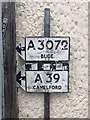
Direction Sign ? Signpost
Located against a house wall on the northwest side of the junction of the A3072 and B3254 Fore Street in Bude Stratton parish. 2 arms and no finial.
Milestone Society National ID: CW_SS2206
Image: © G Digby
Taken: 20 Jul 2019
0.15 miles
10

The Tree Inn, Stratton
A much altered and extended house built before 1610 (see Image).
Image: © Humphrey Bolton
Taken: 7 May 2009
0.16 miles