IMAGES TAKEN NEAR TO
St. Peters Road, BUDE, EX23 9BD
Introduction
This page details the photographs taken nearby to St. Peters Road, EX23 9BD by members of the Geograph project.
The Geograph project started in 2005 with the aim of publishing, organising and preserving representative images for every square kilometre of Great Britain, Ireland and the Isle of Man.

There are currently over 7.5m images from over14,400 individuals and you can help contribute to the project by visiting https://www.geograph.org.uk
Image Map
Images are licensed for reuse under creativecommons.org/licenses/by-sa/2.0
Notes
- Clicking on the map will re-center to the selected point.
- The higher the marker number, the further away the image location is from the centre of the postcode.
Image Listing (28 Images Found)
Images are licensed for reuse under creativecommons.org/licenses/by-sa/2.0
Image
Details
Distance
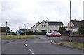
2

Valley, Stratton
The Neet, or Strat valley, seen from Howard Lane.
Image: © Derek Harper
Taken: 21 Jun 2019
0.11 miles
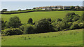
3

Sheep, Stratton
A detail of Image], with sheep on a steep hillside below houses on St Martin's Road.
Image: © Derek Harper
Taken: 21 Jun 2019
0.11 miles
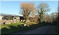
4
Strat valley near Stratton
A detail of Image The houses on the right are on St Martin's Road.
Image: © Derek Harper
Taken: 21 Jun 2019
0.12 miles
5
Union Hill, Stratton
A shortcut available only to westbound traffic on the A3072; if you are eastbound, you must use the junction indicated by the road sign visible in Image On the left is part of the AWB Textiles also shown in that image.
Image: © Derek Harper
Taken: 19 Jan 2017
0.15 miles
6
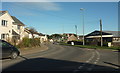
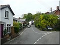
A39, Stratton
The main road, New Road, curves left at this junction with Union Hill, a one-way street climbing from the River Strat. On the right is AWB Textiles, a supplier of healthcare uniforms and workwear.
Image: © Derek Harper
Taken: 19 Jan 2017
0.16 miles
7
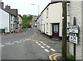
Pre-Worboys road direction sign, Stratton
Most of these old signs have been replaced by ones with place-names in larger upper and lower case letters. The chequer over the A39 box indicates that the road (Bridge Street) leads to the A39. On current signs this is indicated by brackets around the road number.
Image: © Humphrey Bolton
Taken: 7 May 2009
0.17 miles
8
Pre-Worboys road direction sign, Stratton
A second picture of this sign, as seen when driving along the A3072. The sign guides traffic around the corner to the left.
Image: © Humphrey Bolton
Taken: 7 May 2009
0.17 miles
9
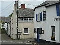
Union Hill, Stratton
The name suggests that there might have been a workhouse here. They were often provided for a group of parishes known as a Poor Law Union.
Image: © Humphrey Bolton
Taken: 7 May 2009
0.17 miles
10
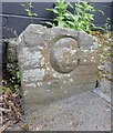
Old Bridge Marker by Union Inn, Union Hill, Bude Stratton parish
Bridge Marker by the UC road, in parish of Bude Stratton (North Cornwall District), Town Bridge, River Strat, against Union House wall on Union Hill - formerly Union Inn.
Surveyed
Milestone Society National ID: CW_STRA01br
Image: © Milestone Society
Taken: Unknown
0.17 miles