IMAGES TAKEN NEAR TO
Granville Terrace, BUDE, EX23 8JZ
Introduction
This page details the photographs taken nearby to Granville Terrace, EX23 8JZ by members of the Geograph project.
The Geograph project started in 2005 with the aim of publishing, organising and preserving representative images for every square kilometre of Great Britain, Ireland and the Isle of Man.

There are currently over 7.5m images from over14,400 individuals and you can help contribute to the project by visiting https://www.geograph.org.uk
Image Map
Images are licensed for reuse under creativecommons.org/licenses/by-sa/2.0
Notes
- Clicking on the map will re-center to the selected point.
- The higher the marker number, the further away the image location is from the centre of the postcode.
Image Listing (214 Images Found)
Images are licensed for reuse under creativecommons.org/licenses/by-sa/2.0
Image
Details
Distance
1

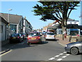
6 Granville Terrace
19th century cottage overlooking the River Neet in Granville Terrace.
Image: © Ian Capper
Taken: 12 Sep 2017
0.01 miles
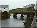
2

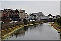
River Neet
The River Neet with the Strand running alongside it on the right. Crossing the river in the background is Nanny Moore's Bridge, with the terraces of Summerleaze Crescent beyond.
Image: © Ian Capper
Taken: 12 Sep 2017
0.01 miles
4
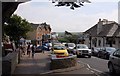
Bude : The River Neet
The river heads through Bude on its way out to the ocean.
Image: © Lewis Clarke
Taken: 4 Jul 2011
0.02 miles
6
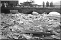
Frozen River Neet, 1947
In the severe winter of 1947 bystanders gaze at the unusual spectacle of ice piled up against the arches of Nanny Moore's Bridge. For a description of the bridge and a more recent view under warmer conditions see Image
Image: © Sinclair Aytoun
Taken: Unknown
0.03 miles
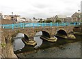
8
Nanny Moore's bridge, Bude
Spanning the River Neet, this footbridge bridge dates from the 18th century, possibly earlier, and was Grade II listed https://www.britishlistedbuildings.co.uk/101141818-nanny-moores-bridge-bude-stratton#.WjoQpvBl-M8 in 1985. The name is in honour of a lady who lived nearby.
Image: © Richard Law
Taken: 1 Oct 2017
0.03 miles
10
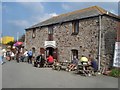
The Brasserie
Situated on the Lower Wharf with the canal opposite, this is a popular eating place.
Image: © Trevor Rickard
Taken: 13 Sep 2007
0.03 miles