IMAGES TAKEN NEAR TO
Marine Drive, BUDE, EX23 0AW
Introduction
This page details the photographs taken nearby to Marine Drive, EX23 0AW by members of the Geograph project.
The Geograph project started in 2005 with the aim of publishing, organising and preserving representative images for every square kilometre of Great Britain, Ireland and the Isle of Man.

There are currently over 7.5m images from over14,400 individuals and you can help contribute to the project by visiting https://www.geograph.org.uk
Image Map
Images are licensed for reuse under creativecommons.org/licenses/by-sa/2.0
Notes
- Clicking on the map will re-center to the selected point.
- The higher the marker number, the further away the image location is from the centre of the postcode.
Image Listing (63 Images Found)
Images are licensed for reuse under creativecommons.org/licenses/by-sa/2.0
Image
Details
Distance
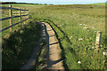
1
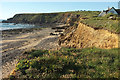
Soft cliffs at Widecombe Bay
Soft cliffs at Widecombe Bay viewed from the South West Coast Path.
Image: © Philip Halling
Taken: 28 Sep 2009
0.02 miles
4
Coast at The Salt House
Looking the other way from Image], and making clear the reason for the inland diversion of the coast path (see Image]), as parts of footpath 525 1/8 have vanished. "In the 1920’s the Old Salt House existed and a road ran in front of it" https://www.cornwall.gov.uk/media/28276846/widemouth-bay.pdf . See also Image
Image: © Derek Harper
Taken: 21 Jun 2019
0.02 miles
5
Coast path near The Salt House
This bit of the coast path takes an inland loop to skirt around The Salt House along 525 1/2. Unfortunately, although footpath 525 1/8 keeps to the coastal edge seaward of the cottages and remains on maps, it has been eroded - see Image] and Image
Image: © Derek Harper
Taken: 21 Jun 2019
0.04 miles
6
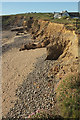
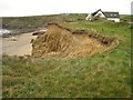
Eroding cliff, The Salt House
Taken from the cliff edge a little south along the coast path shown in Image
Image: © Derek Harper
Taken: 21 Jun 2019
0.05 miles
7
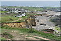
Coast at Salthouse, from the coastal path
The settlement in the distance is Widemouth Bay.
Image: © David Martin
Taken: 26 Apr 2023
0.05 miles
8
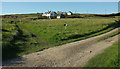
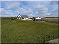
Path and track, The Salt House
Footpath 525 2/1 follows the grassy track on the left; it meets the coast path by the cottages.
Image: © Derek Harper
Taken: 21 Jun 2019
0.05 miles

10
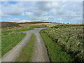
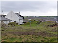
End of the track to Salthouse
The road end of a short access track that leads to the cottages at Salthouse.
Image: © Richard Law
Taken: 5 Oct 2017
0.06 miles