IMAGES TAKEN NEAR TO
St. Annes Close, HOLSWORTHY, EX22 6TG
Introduction
This page details the photographs taken nearby to St. Annes Close, EX22 6TG by members of the Geograph project.
The Geograph project started in 2005 with the aim of publishing, organising and preserving representative images for every square kilometre of Great Britain, Ireland and the Isle of Man.

There are currently over 7.5m images from over14,400 individuals and you can help contribute to the project by visiting https://www.geograph.org.uk
Image Map
Images are licensed for reuse under creativecommons.org/licenses/by-sa/2.0
Notes
- Clicking on the map will re-center to the selected point.
- The higher the marker number, the further away the image location is from the centre of the postcode.
Image Listing (12 Images Found)
Images are licensed for reuse under creativecommons.org/licenses/by-sa/2.0
Image
Details
Distance

2

Bus shelter and a spreading tree at Whitstone
This looks to be careless layout; the seat is positioned so that people using it cannot see an approaching bus because of the telephone box and bus shelter
Image: © David Smith
Taken: 15 Apr 2016
0.03 miles
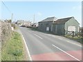
3
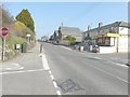
Looking north along the B3254 through Whitstone
From the crossroads to the south of the village stores and post-office (seen here on the right).
Image: © John Baker
Taken: 28 Mar 2013
0.07 miles
4

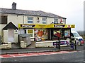
Whitstone village stores and post office
By the B3254, the village is on the watershed between the Tamar flowing south and east, and the much shorter watercourses heading north and west to the Atlantic.
Image: © Jonathan Billinger
Taken: 5 Feb 2008
0.09 miles
6
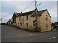
Balsdon Road, Whitstone
Looking across the B3254 at the crossroads at the southern end of Whitstone.
Image: © Derek Harper
Taken: 8 Feb 2008
0.11 miles
7

Whitstone from the south
The name-plate for the village can be seen to the right of the electricity pole beside the B3254.
Image: © John Baker
Taken: 28 Mar 2013
0.13 miles
8

Bungalow in Paradise Park, Whitstone
Paradise Park is a small development of houses and bungalows on the east of the village
Image: © David Smith
Taken: 15 Apr 2016
0.13 miles
9
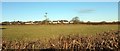
Towards Paradise Park
From the place where Image] was taken, looking across fields to a close of modern houses off the B3254 at Whitstone.
Image: © Derek Harper
Taken: 19 Jan 2017
0.15 miles
10
18th-century Methodist meeting house
Up for sale beside the B3254, on the outskirts of Whitstone.
Image: © John Baker
Taken: 28 Mar 2013
0.16 miles