IMAGES TAKEN NEAR TO
HOLSWORTHY, EX22 6JS
Introduction
This page details the photographs taken nearby to EX22 6JS by members of the Geograph project.
The Geograph project started in 2005 with the aim of publishing, organising and preserving representative images for every square kilometre of Great Britain, Ireland and the Isle of Man.

There are currently over 7.5m images from over14,400 individuals and you can help contribute to the project by visiting https://www.geograph.org.uk
Image Map
Images are licensed for reuse under creativecommons.org/licenses/by-sa/2.0
Notes
- Clicking on the map will re-center to the selected point.
- The higher the marker number, the further away the image location is from the centre of the postcode.
Image Listing (10 Images Found)
Images are licensed for reuse under creativecommons.org/licenses/by-sa/2.0
Image
Details
Distance
1
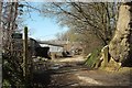
Manworthy Mill
On a bend on the road to the new livestock market. The footpath indicated on the left, Holsworthy Hamlets Footpath 9 (shown in Image]), manages four sharp bends in its zigzag course of less than 600 metres.
Image: © Derek Harper
Taken: 23 Apr 2016
0.03 miles

3

Lane at Manworthy Mill
At the same spot as Image] and Image, with the lane bending past the entrance to the mill. It's followed by the parish boundary between Holsworthy Hamlets (left) and Holsworthy.
Image: © Derek Harper
Taken: 23 Apr 2016
0.05 miles
4

Lane at Manworthy Mill
Looking in the opposite direction to Image], into the sun. The parishes have changed sides, therefore; Holsworthy Hamlets is now on the right and Holsworthy on the left.
Image: © Derek Harper
Taken: 23 Apr 2016
0.07 miles
5
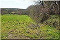
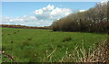
Pasture, Manworthy Mill
Holsworthy Hamlets Footpath 9 sets out from the sign shown in Image
Image: © Derek Harper
Taken: 23 Apr 2016
0.08 miles
6
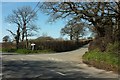
Junction near Little Gulliver Bridge
Trewyn Road passes the lane past Manworthy Mill. The parish boundary between Holsworthy Hamlets and Holsworthy comes down the main road on the left and then turns up the lane on the right; the camera is in Holsworthy.
Image: © Derek Harper
Taken: 23 Apr 2016
0.15 miles
7
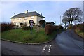
Houses at the Junction
On a road junction near Gulliver Bridge.
Image: © Tony Atkin
Taken: 17 Jan 2010
0.15 miles
8
Field by Trewyn Road
Taken across the road from Image], with trees along a small stream on the right.
Image: © Derek Harper
Taken: 23 Apr 2016
0.17 miles
9

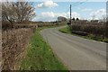
Trewyn Road
A reverse view of Image], with the opposite parapet of Little Gulliver Bridge, and the junction shown in Image
Image: © Derek Harper
Taken: 23 Apr 2016
0.17 miles
10
Trewyn Road
Heading into Holsworthy, with a welcoming sign on the bend, and seen from the same spot as Image], with a parapet of Little Gulliver Bridge over on the right.
Image: © Derek Harper
Taken: 23 Apr 2016
0.20 miles