IMAGES TAKEN NEAR TO
Penrose Terrace, Bodmin Street, HOLSWORTHY, EX22 6BQ
Introduction
This page details the photographs taken nearby to Penrose Terrace, Bodmin Street, EX22 6BQ by members of the Geograph project.
The Geograph project started in 2005 with the aim of publishing, organising and preserving representative images for every square kilometre of Great Britain, Ireland and the Isle of Man.

There are currently over 7.5m images from over14,400 individuals and you can help contribute to the project by visiting https://www.geograph.org.uk
Image Map (Loading...)


Getting Data...Please wait
Leaflet Map data © OpenStreetMap
Images are licensed for reuse under creativecommons.org/licenses/by-sa/2.0
Notes
- Clicking on the map will re-center to the selected point.
- The higher the marker number, the further away the image location is from the centre of the postcode.
Image Listing (81 Images Found)
Images are licensed for reuse under creativecommons.org/licenses/by-sa/2.0
Image
Details
Distance
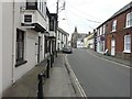
2
Bodmin Street, Holsworthy
Taken a little further west, and with a slightly clearer view of the two listed buildings: The United Methodist Church and Church Hall https://www.historicengland.org.uk/listing/the-list/list-entry/1104938 and the 4-bay blue house on this side of it https://www.historicengland.org.uk/listing/the-list/list-entry/1104937 . On the right is the Golden Fleece pub.
Image: © Derek Harper
Taken: 23 Apr 2016
0.03 miles
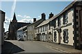
3
Bodmin Street, Holsworthy
The United Methodist Church and Church Hall are listed https://www.historicengland.org.uk/listing/the-list/list-entry/1104938 : "A good example of an early C20 Methodist church with a large and enthusiastic community". On this side of it, the light blue house is described at https://www.historicengland.org.uk/listing/the-list/list-entry/1104937 .
Image: © Derek Harper
Taken: 23 Apr 2016
0.04 miles
4

Holsworthy station (remains), 1995
View eastward, towards Halwill Junction: ex-LSWR Bude branch from Halwill Junction on the Exeter - Okehampton - Padstow/Plymouth lines, closed 3/10/66.
Image: © Ben Brooksbank
Taken: 24 Apr 1995
0.05 miles
5

HATS Theatre Holsworthy
This art deco former cinema has been saved by recladding the main building to provide a home for the thriving Holsworthy Amateur Theatre Society. A magnificent pantomime is performed each year.
Image: © Robert Walden
Taken: 27 Oct 2007
0.06 miles
6

The Great Tree plaque, Stanhope Square, Holsworthy
Set into the road to mark the position of the elm tree from where, since Saxon times, the Royal Proclamation was read at the beginning of St Peter's Fair.
Image: © Humphrey Bolton
Taken: 6 Apr 2010
0.06 miles

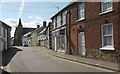
8

The Old Market Inn, Holsworthy
On Chapel Street, the main road to the south. A real ale pub.
Image: © Humphrey Bolton
Taken: 6 Apr 2010
0.07 miles
9

Car park, Holsworthy
The Waitrose car park. This is the former site of Holsworthy station.
Image: © Derek Harper
Taken: 12 Aug 2013
0.07 miles
10
The former Manor House, Holsworthy
This had become the rectory by 1717, and was enlarged twice. The Urban District Council purchased it in 1947 for use as offices. (Information from the town trail booklet)
Image: © Humphrey Bolton
Taken: 6 Apr 2010
0.08 miles