IMAGES TAKEN NEAR TO
Sheepwash, BEAWORTHY, EX21 5NT
Introduction
This page details the photographs taken nearby to EX21 5NT by members of the Geograph project.
The Geograph project started in 2005 with the aim of publishing, organising and preserving representative images for every square kilometre of Great Britain, Ireland and the Isle of Man.

There are currently over 7.5m images from over14,400 individuals and you can help contribute to the project by visiting https://www.geograph.org.uk
Image Map
Images are licensed for reuse under creativecommons.org/licenses/by-sa/2.0
Notes
- Clicking on the map will re-center to the selected point.
- The higher the marker number, the further away the image location is from the centre of the postcode.
Image Listing (11 Images Found)
Images are licensed for reuse under creativecommons.org/licenses/by-sa/2.0
Image
Details
Distance
1
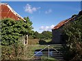
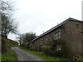
Barns at East Totleigh
This pair of stone barns, roofed with corrugated iron, are beside the lane to Hatherleigh.
Image: © Derek Harper
Taken: 4 Oct 2007
0.01 miles
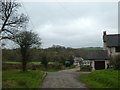
3
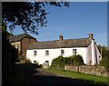
East Totleigh
East Totleigh Barton farmhouse, with a barn conversion to the left. The buildings are on the lane from Hatherleigh to Sheepwash, in a steep little side valley close to the Torridge valley.
Image: © Derek Harper
Taken: 4 Oct 2007
0.06 miles
7
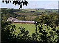
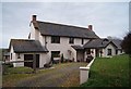
Bremridge
The farm at Bremridge seen from beside the lane from Hatherleigh, and across the field shown in Image The buildings visible above the farmhouse are at East Totleigh; Allers Copse, the woodland beyond that, is in Image and Image
Image: © Derek Harper
Taken: 4 Oct 2007
0.10 miles
8
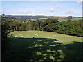
Heaver Close Copse
The edge of the copse, adjoining this field by the lane from Hatherleigh to Sheepwash, is in this square, but it drops down the valley side of the Torridge into Image On the floor of the valley can be seen the farm at Hele Barton.
Image: © Derek Harper
Taken: 4 Oct 2007
0.14 miles
9
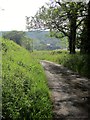
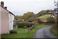
Lane to Bremridge
Dropping into the Torridge valley.
Image: © Derek Harper
Taken: 31 May 2014
0.19 miles
10
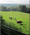
Sheep near Bremridge
The view shown nearly seven years earlier in Image, with nearby sheep.
Image: © Derek Harper
Taken: 31 May 2014
0.20 miles