IMAGES TAKEN NEAR TO
Jacobstowe, OKEHAMPTON, EX20 3RE
Introduction
This page details the photographs taken nearby to EX20 3RE by members of the Geograph project.
The Geograph project started in 2005 with the aim of publishing, organising and preserving representative images for every square kilometre of Great Britain, Ireland and the Isle of Man.

There are currently over 7.5m images from over14,400 individuals and you can help contribute to the project by visiting https://www.geograph.org.uk
Image Map
Images are licensed for reuse under creativecommons.org/licenses/by-sa/2.0
Notes
- Clicking on the map will re-center to the selected point.
- The higher the marker number, the further away the image location is from the centre of the postcode.
Image Listing (34 Images Found)
Images are licensed for reuse under creativecommons.org/licenses/by-sa/2.0
Image
Details
Distance
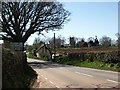
3
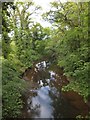
The new road bridge, Jacobstowe
The A3072 bridge over the River Okement replaces an older bridge which was approached via a sharp bend in the road on the east bank
Image: © David Smith
Taken: 5 Jun 2013
0.14 miles
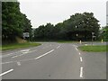
4
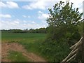
Field beside River Okement
The trees at the further side of the field are on the bank of the river
Image: © David Smith
Taken: 5 Jun 2013
0.15 miles
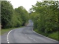
5
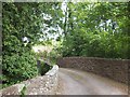
Jacobstowe Bridge over River Okement
This was the original road east from Jacobstowe, taking a sharp right hand turn on the east side. It passes a former mill on the west bank
Image: © David Smith
Taken: 5 Jun 2013
0.15 miles
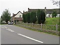
6
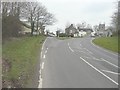
Approaching Jacobstowe from the east-northeast
Along the A3072 near to the junction with the B3216 (seen here heading left). The church is that of St James, while to its left is the house called The Old School Room.
Image: © John Baker
Taken: 26 Mar 2013
0.15 miles
8
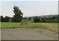
Picnic area - Jacobstowe
Early online images just show this as a field opposite the church.
Image: © Fernweh
Taken: 17 Aug 2016
0.16 miles
9
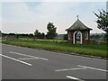
A spot for a pause
This had been fairly recently added as it does not appear on the most recent Google street view images taken in 2011. I suspect it was intended for people walking the long distance footpath known as the Tarka Trail which passes through Jacobstowe.
Image: © Fernweh
Taken: 17 Aug 2016
0.17 miles