IMAGES TAKEN NEAR TO
Normandy Place, OKEHAMPTON, EX20 3JQ
Introduction
This page details the photographs taken nearby to Normandy Place, EX20 3JQ by members of the Geograph project.
The Geograph project started in 2005 with the aim of publishing, organising and preserving representative images for every square kilometre of Great Britain, Ireland and the Isle of Man.

There are currently over 7.5m images from over14,400 individuals and you can help contribute to the project by visiting https://www.geograph.org.uk
Image Map
Images are licensed for reuse under creativecommons.org/licenses/by-sa/2.0
Notes
- Clicking on the map will re-center to the selected point.
- The higher the marker number, the further away the image location is from the centre of the postcode.
Image Listing (61 Images Found)
Images are licensed for reuse under creativecommons.org/licenses/by-sa/2.0
Image
Details
Distance
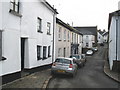
1

Corner house, Park Road, Hatherleigh
Image: © Roger Cornfoot
Taken: 24 Jan 2009
0.14 miles
3
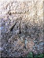
Ordnance Survey Cut Mark
This OS cut mark can be found on Hatherleigh Cross. It marks a point 122.119m above mean sea level. http://www.geograph.org.uk/photo/3860219
Image: © Adrian Dust
Taken: 18 Feb 2014
0.16 miles
4

Hatherleigh Cross
There is an OS cut mark at the base. http://www.geograph.org.uk/photo/3860218
Image: © Adrian Dust
Taken: 18 Feb 2014
0.16 miles
5

Old Wayside Cross at Stoning Cross, Hatherleigh
Hatherleigh Park Cross (Stoning), old head, shaft and base, by the UC road, in parish of Hatherleigh (West Devon District), Stoning Cross, East end of Park Road at junction with Victoria Road, on a bank below the signpost and telegraph pole.
Grade II listed.
List Entry Number: 1165724 https://historicengland.org.uk/listing/the-list/list-entry/1165724
Scheduled Monument.
List Entry Number: 1013715 https://historicengland.org.uk/listing/the-list/list-entry/1013715
Surveyed
Milestone Society National ID: DVWD_HAT02
Image: © Alan Rosevear
Taken: 19 Jun 2010
0.16 miles

7
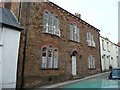
The Old Police Station, South Street, Hatherleigh
Surprisingly this does not have a datestone, but it was probably built in the late 19C.
Image: © Humphrey Bolton
Taken: 10 Apr 2010
0.18 miles
8

Late 18C house, Higher Street, Hatherleigh
At the junction with South Street and High Street. Altered in the 19C, when it was divided into two houses. There was a sign for bed and breakfast.
Image: © Humphrey Bolton
Taken: 10 Apr 2010
0.18 miles

10
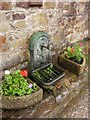
Roadside tap, High Street, Hatherleigh
Mapped as a well, this is outside number 5.
Image: © Derek Harper
Taken: 15 Aug 2013
0.18 miles