IMAGES TAKEN NEAR TO
Merton, OKEHAMPTON, EX20 3DW
Introduction
This page details the photographs taken nearby to EX20 3DW by members of the Geograph project.
The Geograph project started in 2005 with the aim of publishing, organising and preserving representative images for every square kilometre of Great Britain, Ireland and the Isle of Man.

There are currently over 7.5m images from over14,400 individuals and you can help contribute to the project by visiting https://www.geograph.org.uk
Image Map
Images are licensed for reuse under creativecommons.org/licenses/by-sa/2.0
Notes
- Clicking on the map will re-center to the selected point.
- The higher the marker number, the further away the image location is from the centre of the postcode.
Image Listing (4 Images Found)
Images are licensed for reuse under creativecommons.org/licenses/by-sa/2.0
Image
Details
Distance
1

Lane near Pinkhill Farm
The lane from the farm to Brandis Corner, with a threatening sky to the west.
Image: © Derek Harper
Taken: 26 Sep 2007
0.14 miles
2

Merton Methodist Church
This appears to have been converted into a private dwelling, but has been renovated very sympathetically. The road is the A386 between Merton and Great Torrington. The telephone box shown on maps has vanished.
Image: © Derek Harper
Taken: 30 Oct 2007
0.19 miles
3

Former chapel, north of Merton
The building has been converted into a private house.
Image: © David Smith
Taken: 9 May 2013
0.20 miles
4
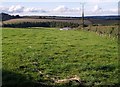
Field at Pinkhill Farm
The roofs of a couple of the farm's barns peep above the grass. The conifer wood is Furzehill Plantation, largely in SS5114.
Image: © Derek Harper
Taken: 26 Sep 2007
0.20 miles