IMAGES TAKEN NEAR TO
Grove Meadow, OKEHAMPTON, EX20 2NE
Introduction
This page details the photographs taken nearby to Grove Meadow, EX20 2NE by members of the Geograph project.
The Geograph project started in 2005 with the aim of publishing, organising and preserving representative images for every square kilometre of Great Britain, Ireland and the Isle of Man.

There are currently over 7.5m images from over14,400 individuals and you can help contribute to the project by visiting https://www.geograph.org.uk
Image Map
Images are licensed for reuse under creativecommons.org/licenses/by-sa/2.0
Notes
- Clicking on the map will re-center to the selected point.
- The higher the marker number, the further away the image location is from the centre of the postcode.
Image Listing (90 Images Found)
Images are licensed for reuse under creativecommons.org/licenses/by-sa/2.0
Image
Details
Distance
1
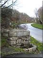
Lady Well at Sticklepath
Situated beside the old A30 road. The inscription reads 'Drink and be thankful'.
Image: © Rod Allday
Taken: 27 Jan 2012
0.02 miles
2

Cleave Mill Cottages, Sticklepath
This row of cottages backing on to the lane to Skaigh were part of Cleave Mill, on the River Taw.
Image: © Derek Harper
Taken: 21 May 2010
0.03 miles
3

The west end of Sticklepath
Note the building on the right with a row of south-facing windows (was it a workshop of some kind?)
Image: © David Smith
Taken: 12 Oct 2011
0.03 miles
4
St. Mary, Sticklepath
An 1875 replacement of an earlier chantry chapel.
Image: © Jonathan Thacker
Taken: 16 Sep 2018
0.03 miles

6
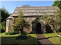
St Mary's church, Sticklepath
Overlooked by Cherry and Pevsner, this little church dates from 1875, replacing "a curious old cob thatched chapel" http://www.northmoor-churches.org/St%20Mary%20Sticklepath.htm .
Image: © Derek Harper
Taken: 21 May 2010
0.04 miles
7

Remains of Ladywell Cross by the former A30, Sticklepath
Ladywell Cross, old shaft by the UC Road (was A30), in parish of Sticklepath (West Devon District), junction with a lane that leads to the hamlet of Skaigh, 110m Northwest of St Mary's church, very high on a bank above the junction, amongst bushes.
Scheduled Monument.
List Entry Number: 1019216 https://historicengland.org.uk/listing/the-list/list-entry/1019216
Surveyed
Milestone Society National ID: DVWD_STI01
Image: © Alan Rosevear
Taken: 19 Jun 2010
0.04 miles
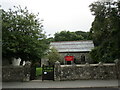
8
Sticklepath Village Hall
A former school.
Image: © Jonathan Thacker
Taken: 16 Sep 2018
0.07 miles
9
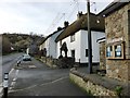
Junction of Back Lane with the main road through Sticklepath
Image: © David Gearing
Taken: 28 Jan 2016
0.07 miles
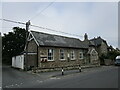
10

Sticklepath Village Hall and Post Office
Image: © David Smith
Taken: 12 Oct 2011
0.07 miles