IMAGES TAKEN NEAR TO
Honeychurch, NORTH TAWTON, EX20 2AG
Introduction
This page details the photographs taken nearby to EX20 2AG by members of the Geograph project.
The Geograph project started in 2005 with the aim of publishing, organising and preserving representative images for every square kilometre of Great Britain, Ireland and the Isle of Man.

There are currently over 7.5m images from over14,400 individuals and you can help contribute to the project by visiting https://www.geograph.org.uk
Image Map
Images are licensed for reuse under creativecommons.org/licenses/by-sa/2.0
Notes
- Clicking on the map will re-center to the selected point.
- The higher the marker number, the further away the image location is from the centre of the postcode.
Image Listing (12 Images Found)
Images are licensed for reuse under creativecommons.org/licenses/by-sa/2.0
Image
Details
Distance
1
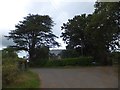
The Old Rectory, Honeychurch
Honeychurch ceased to be a separate parish in 1927. The rectory appears Victorian; on the left is a Lebanon Cedar, a reminder of the comparative wealth of some clergy, who could afford exotic trees.
Image: © David Smith
Taken: 29 Aug 2013
0.01 miles
2
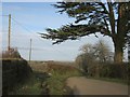
Lane past The Old Rectory, Honeychurch
A peek round the corner in Image, with the same cedar tree and a gate into a field.
Image: © Derek Harper
Taken: 20 Feb 2012
0.02 miles
3
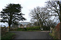
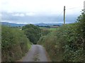
Sampford Courtenay: by The Old Rectory, Honeychurch
Looking north on the lane to Venn Copse Cross
Image: © Martin Bodman
Taken: 11 Feb 2007
0.03 miles
4
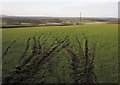
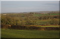
Field near Honeychurch
A view through a gateway close to where Image was taken. The distant village, beyond some still frosty fields, is Exbourne.
Image: © Derek Harper
Taken: 20 Feb 2012
0.06 miles
5
The rector's view, Honeychurch
This is the view that the rector of Honeychurch would see every time he set out for the village - apart from the tarmac. The minor road drops towards the village. On the skyline are the northern heights of Dartmoor, with Belstone more or less straight ahead.
Image: © David Smith
Taken: 29 Aug 2013
0.08 miles
6
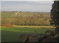
Countryside near Honeychurch
From the lane between the village and Fishingclose Cross, looking across the head of the valley of a headwater of the Hole Brook. The distant barn just right of centre, and the fields near it, are in Image
Image: © Derek Harper
Taken: 20 Feb 2012
0.14 miles
7
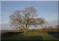
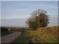
Tree above Honeychurch
From the bend shown in Image
Image: © Derek Harper
Taken: 20 Feb 2012
0.17 miles
8
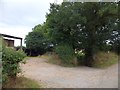
Footpath in a cutting leading to Bude
The road leads to the right; straight ahead is the start of a track which drops to follow a stream to the remote farm at Bude.
Image: © David Smith
Taken: 29 Aug 2013
0.19 miles
9
Trees by the lane near Honeychurch
From the spot where Image was taken, with trees overlooking a right-angled bend which takes the lane down into the village.
Image: © Derek Harper
Taken: 20 Feb 2012
0.19 miles
10
Countryside near Honeychurch
From the same spot as Image, looking to the right, with trees in the valley head mentioned at Image, and the rpominent farm at Lewersland in Image
Image: © Derek Harper
Taken: 20 Feb 2012
0.20 miles